| Friday, 31 July 1998 | |
| We left St. Louis after work on Friday. With construction on the I-70 bridge over the Missouri River at St. Charles ongoing, traffic on I-64/Hwy 40 was even worse than the usual Friday rush-hour disaster. Finally, we broke free and headed on to Kansas City. |
| Saturday, 1 August 1998 | |
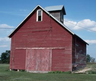
| Saturday, we headed north toward Iowa. We stopped off at the Pony Express museum in St. Joseph, MO, then continued up I-29 to Sioux City, Iowa, where we headed off on country roads toward the Iowa highpoint. Between the description in Zumwalt's book and my newly-acquired GPS, we had no difficulty finding the farm containing the highpoint. The owners were home and greeted us with typical Midwestern hospitality. |
 |
 |
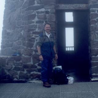
They informed us that the highpoint now has an official name, "Hawkeye Point". What was a cattle feedlot is now open space between their remaining barn and a cornfield, and they have installed a summit log in the former feeding trough, replete with Iowa-shaped highpoint key chains (free, one to a family, but we chipped in a buck to offset whatever costs were involved). Recording the way point on the GPS showed 43° 27.608' north, 95° 42.523' west. We took the requisite summit photos and signed the log before heading on north to I-90 in Worthington, MN, for the night. |
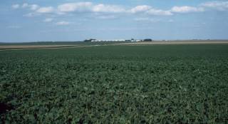
| The view from the highpoint is expansive, even if there isn't much vertical relief apparent. Good Iowa farmland, lots of soybeans and corn, depending upon which way you look. |
 |
| Sunday, 2 August 1998 |
| Travel day...left Worthington, MN, in a light drizzle, which deteriorated to an on-and-off heavy rain. The Harley-Davidson crowd on their way to Sturgis, SD, were having a much more difficult time than we were. Later in the afternoon, the steady rain finally stopped and the sky cleared. We arrived at Wall, SD, for the night. |
| Monday, August 3, 1998 | |
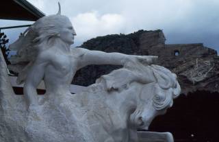
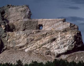
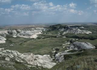
| Still raining...so we slept in a bit. Drove back to the eastern entry point to the Badlands, and made our way through the scenic loop which winds from there back west to Wall. We continued on past Rapid City, and down Highway 16 to Custer. When we checked into the motel, we found we had enough "spare" time to visit the Crazy Horse memorial-in-process, since it was a mere five miles from Custer. | |
 |
 |
| Tuesday, August 4, 1998 | |
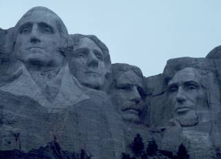
| When we awoke, it wasn't raining, but the clouds had closed in on the Black Hills. We drove over to Mt. Rushmore and managed to see the presidents through breaks in the fog and clouds. After Mt. Rushmore, we drove over to Sylvan lake. The rain picked up from time to time, and I decided that Nathan's rain gear would not be up to a steady downpour, and he stayed with Marcia while I hiked up to Harney Peak. The trail head for trail number 9 starts off on a gravel jeep road, then turns right off the jeep road after a little more than a half-mile. It then winds the remaining 2-1/2 miles to the summit of Harney Peak. You start off at about 6200', climb to 6600', drop back to 6400', then begin the push to the summit. The trail is well-traveled...I encountered 15 or 20 people, total, both ways. |
 |
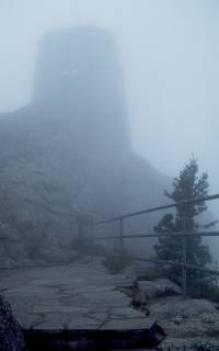 |
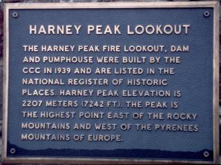
According to the guide book, the trail is blazed and blazes are branded with the number 9. However, I spotted at most a half-dozen blazes through the length of the trail. Fortunately, there are signs at each trail junction, so there is little problem with following the correct trail, even in a 100-foot-visibility cloud/fog. As the trail approaches the summit, there are numerous rock and metal steps which climb to the lookout tower on the summit, proper. Once in the CCC-constructed tower, the clouds prevented seeing more than a few of the summit rocks at the base of the tower. So much for the "panoramic view" promised by the Harney Peak postcards! A snack, a few photos to document what the place looks like shrouded in a ghostly fog, and I hit the trail back to Sylvan Lake. GPS data...the trail head for trail 9 at the Sylvan Lake Day Use Area is 43° 50.874' N, 103° 33.642' W, while the summit is 43° 51.959' N, 103° 31.869'W. Transit time for me was 1 hour, 15 minutes to the summit, about an hour on the way back. |
 |
 |
| Wednesday, 5 August 1998 | |
| The morning dawned with a bit of sunshine in Custer, SD. We drove north and then west and picked up US highway 85 north into North Dakota. As we neared Amidon, ND, we followed a combination of local directions and GPS headings to locate the Buzalsky farm near which White Butte, the ND highpoint, is located. Heading north from Bowman, ND, watch the mile markers on US 85. |
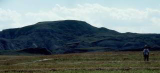 |
| Turn right on the section road just north of milepost 29, about 12 miles north of Bowman. (46° 20.262' N, 103° 21.749'W). Follow this road four miles to the N/S section road and turn left (north) (46° 20.292'N, 103° 16.749'W), continuing north 3.5 miles to the Buzalsky farm (46° 23.424'N, 103° 16.857'W). From there, after asking permission to cross private land, head generally west along the fence lines toward White Butte. There are several fence lines to cross before heading out into a mini-badlands area leading up to White Butte proper. | |
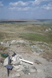 |
Route finding is no real problem, as long as you follow Mr. Buzalsky's suggestion of staying to the north side of the summit. Shortly after crossing the last fence line, you will find a series of stock trails which meander through relatively easy parts of the various draws and gullies. As you head up further, you will pick up a use trail which follows the summit ridge on the north/west side of the butte. This trail follows the ridge south and leads directly to the highpoint marker, a USGS benchmark to which the Buzalkskys have added a memorial marker to a family member, and a summit log in a steel box. The summit proper is located at 46° 23.228'N, 103° 18.121'W. Finding the way back is easy enough even without a GPS, as the Buzalsky farm is visible for much of the route, and a bit of care avoiding the deeper/steeper gullies is all that is required. Stock trails abound, and these will generally keep you away from the few really steep bits of land between the summit and the farm. |
 |
 |
|
Nathan pooped out about halfway up...it was quite sunny and a bit
warm, and he wasn't motivated to tramp through the weeds and
occasional brush, so I planted him under a convenient lone tree
to wait for me on the way back. Time to the summit was about an
hour, with a few delays before Nathan decided to sit this one out,
and farm-to-farm time was just a bit under two hours, including
about 15 minutes on the summit to take photos and sign the log.
We then drove back south a bit to Bowman, ND, for the night. |
|
| Thursday, 6 August 1998 | |
| Another travel day. We continued on to Chadron, Nebraska, for the night. | |
| Friday, 7 August 1998 | |
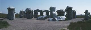
| We drove down to the southwest corner of the "panhandle" of Nebraska. Along the way, we stopped briefly just north of Alliance to visit Carhenge, a replica of Stonehenge constructed of junk autos. Too bad it wasn't the summer solstice, or we could have checked out the alignment of the site. |
 |
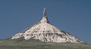 |
Then a quick detour past Bridgeport to see Chimney Rock, since Nathan had learned about the Oregon Trail in school this spring, and Chimney Rock is one of the famous landmarks from that trail. |
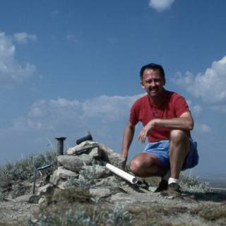
| We read that the Chamber of Commerce in Kimball, NE, hands out certificates to people visiting "Panorama Point", the highpoint of Nebraska, so we stopped by and found that they had both the certificates and a detailed map which proved quite helpful in finding our way down along the section roads to the NE highpoint. Indeed, there is now a "road", or at least a pair of well-beaten ruts, all the way to the highpoint marker. We arrived there about four in the afternoon, just in time to meet another highpointer seeking the same spot. The highpoint is at 41° 0.462'N, 104° 1.854' W. |
 |
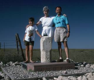 |
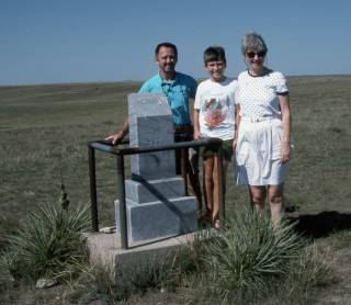
After visiting the NE highpoint, we returned to the section roads and followed the directions on the map from the C-of-C to find the "three corners" marker which sits at the Colorado/Nebraska/Wyoming intersection. We took the requisite photo of the three of us standing, together, each in a different state. The marker is at 41° 0.101'N, 104° 3.153'W. (Hmm...does that mean my GPS is off by 0.101 minutes on that measurement, or is the surveying of the marker a little in error?) |
| Saturday, 8 August 1998...Sunday, 9 August 1998 |
| Really headed home now...via Ogallala, NE, St. Joseph, MO, finally down to Kansas City, then across I-70 and back home. Seven states (IA, MN, SD, ND, NE, WY, CO), four high points, and uncounted Harley-Davidson hogs anywhere within 50 miles of Rapid City, SD...a great trip, and a total of 2,936 miles on the Saab. |