Jakk's Glade: The Jack Longacre Memorial
and Highpoint Signposts

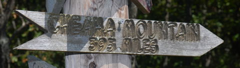
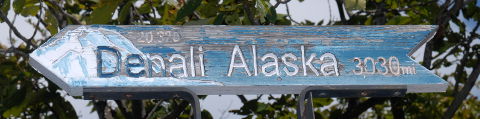
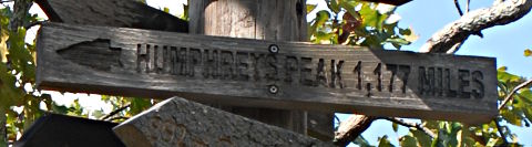
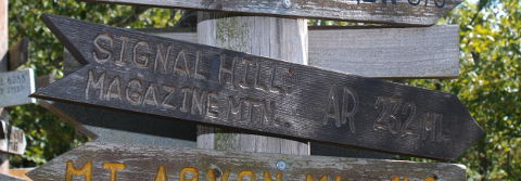
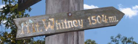
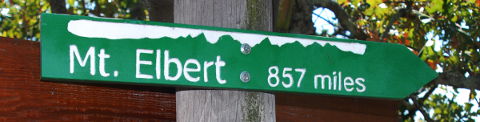
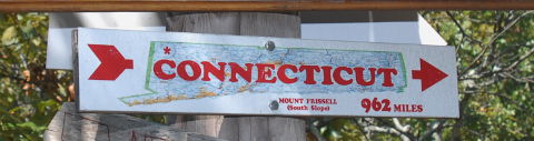
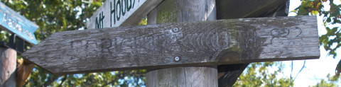
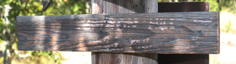
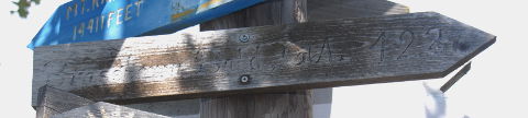
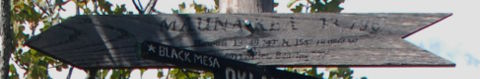
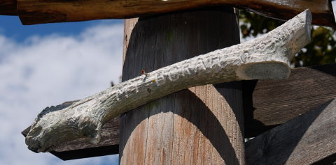
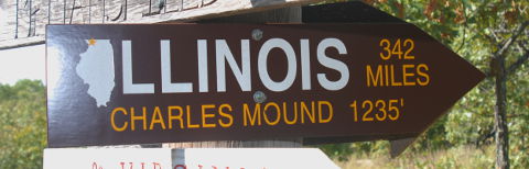
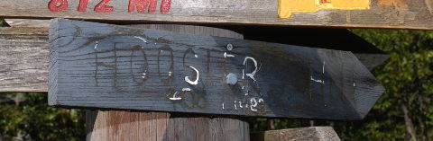
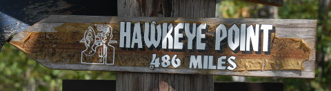
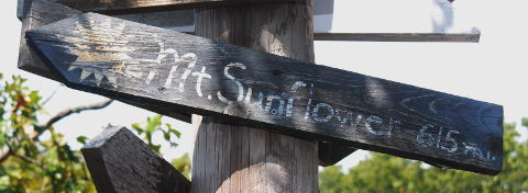
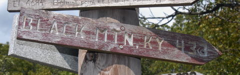
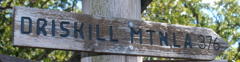
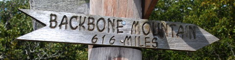
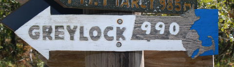
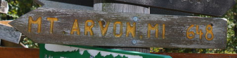
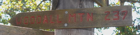
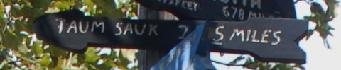
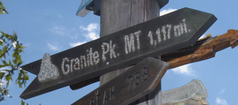
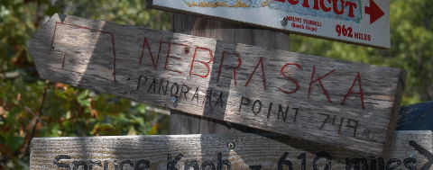
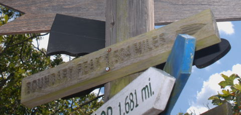
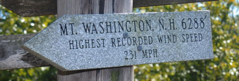
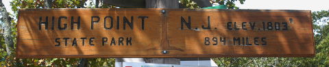
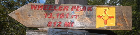
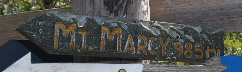
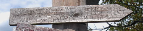
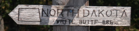
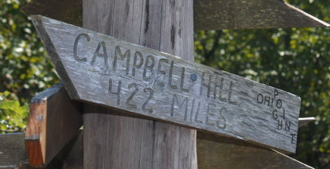
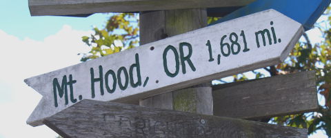
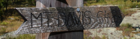
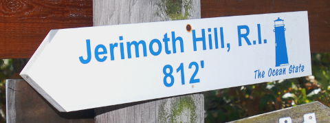
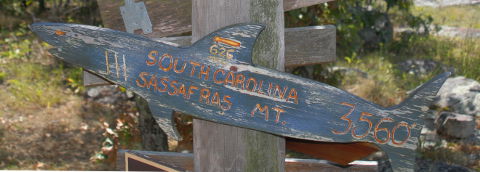
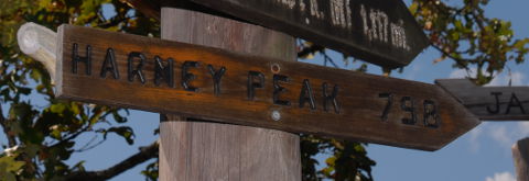
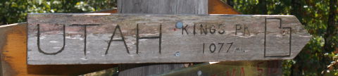
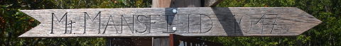
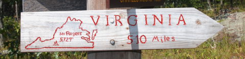
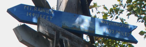
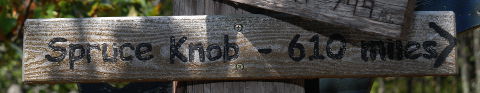
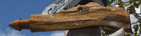
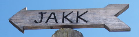
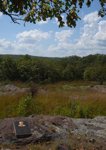
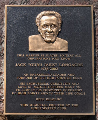
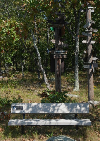
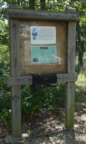
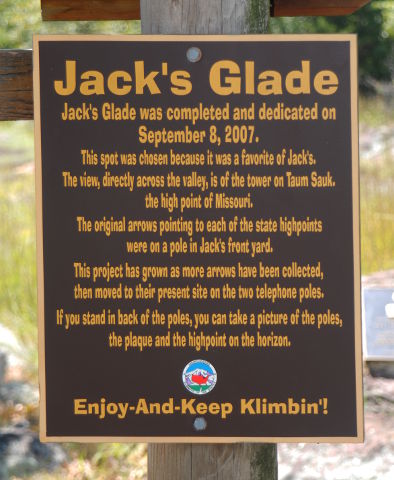
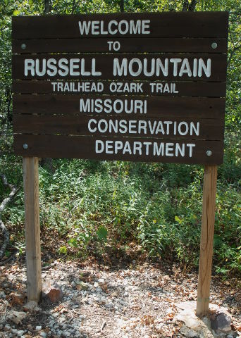
On Russell Mountain, close to the Missouri state highpoint on Taum Sauk Mountain, there is an open glade with a view over to Taum Sauk. In this glade, there are a memorial plaque, a bench and two telephone poles with arrows pointing to the various state highpoints.

Known as "Jakk's Glade," it is a memorial to Jack "Guru Jakk" Longacre, the founder of the Highpointers Club. It is altogether appropriate that the arrow atop one of the telephone poles pointing to "JAKK" is a weathervane. Jack is all around us and present at each of the 50 state highpoints. The Club made the effort to scatter a bit of Jack's ashes at each of the highpoints after his death. Wherever you are in the United States, Jack is looking down and watching over you as you climb.

The Ozark Trail Association recently relocated their Russell Mountain trailhead to coincide with the trailhead leading from Highway CC out to Jakk's Glade. This will increase traffic through the Glade and, hopefully, spark some curiosity about the Club and encourage some of the Ozark Trail hikers to seek us out and join the Club.

As the Club liaison for Taum Sauk, I have also taken on responsibility for maintaining the highpoint arrows. These have been made by various club members and, with age and weather, need periodic replacement. In addition, according to my latest inventory in September, 2014, there are four states whose arrows are missing or have never been made.

If you look down the table below and see anything marked "poor" or "missing" in the "Condition" column, please consider making a replacement arrow. You may contact me via email and I will get in touch with you about shipping me the replacement arrow. This is purely a volunteer effort but one that we should keep up with so folks realize what the Club is all about and that we truly appreciate the work of our founder and others who have gone before us.

There are very few "hard and fast" rules for making the arrows. In general, they ought to be about 6" tall and 36" to 48" long. Many are carved, some even in the shape of the states they represent. Having the name or abbreviation of the state as well as the highpoint name will make it easier for non-highpointers to identify. Many of the arrows include the highpoint elevation and distance from the Glade to the highpoint. Feel free to use your creativity but remember that this is an outdoor display so the arrows will be exposed to Missouri's unpredictable conditions. Arrows will be attached to the poles with two screws at the midpoint of the arrow, so leaving space there without disturbing your lettering or artwork would be preferable. Refer to the existing arrows for examples.

The distance and bearing to each highpoint are calculated from Jakk's Glade and included in the table below in case you want to incorporate those on the arrow. When I attach arrows to the poles, I attempt to align the arrow with the initial bearing to that highpoint. All distances and bearings below were computed using the "haversine" formula as shown on the Movable Type Scripts web site.

State Highpoint Arrow Condition Altitude Lat/Lon Distance Bearing
Alabama Cheaha Mountain

Good

2,407 33°29.140'N,
85°45.848'W
394.5 miles 134°22'
Alaska Mount McKinley /
Denali

Fair

20,320 63°4.164'N,
151°0.446'W
3090.7 miles 325°16'
Arizona Humphreys Peak

Good

12,633 35°20.786'N,
111°40.677'W
1173.2 miles 269°0'
Arkansas Magazine Mountain

Good

2,753 35°10.039'N,
93°38.695'W
233.3 miles 225°29'
CA Mount Whitney

Good

14,497 36°34.721'N,
118°17.466'W
1,516.8 miles 275°53'
CO Mount Elbert

Good

14,433 39°7.065'N,
106°26.686'W
858.7 miles 272°11'
CT Mount Frissel
(south slope)

Good

2,380 39°50.149'N,
75°31.164'W
962.5 miles 65°53'
DE Ebright Azimuth
(Tower Hill)

Poor

448 39°50.149'N,
75°31.164'W
832.0 miles 74°29'
FL Britton Hill

Poor

345 30°57.313'N,
86°16.913'W
546.5 miles 151°11'
GA Brasstown Bald

Poor

4,784 34°52.457'N,
83°48.654'W
426.7 miles 113°49'
HI Mauna Kea

Poor

13,796 19° 49.242'N,
155° 28.086'W
4032.1 miles 271°38'
ID Borah Peak

Fair

12,662 44° 08.217'N,
113° 46.620'W
1283.1 miles 297°58'
IL Charles Mound

Good

1,235 42° 30.213'N,
90° 14.381'W
341.6 miles 3°57'
IN Hoosier Hill

Poor

1,257 40°0.060'N,
84°50.932'W
357.0 miles 60°9'
IA Hawkeye Point

Good

1,670 43°27.608'N,
95°42.523'W
484.3 miles 325°27'
KS Mount Sunflower

Fair

4,039 39°1.316'N,
102°2.235'W
676.1 miles 282°39'
KY Black Mountain

Fair

4145 36°54.855'N,
82°53.648'W
431.7 miles 93°40'
LA Driskill Mountain

Good

535 32°25.481'N,
92°53.776'W
376.7 miles 199°54'
ME Mount Katahdin

Missing!

5,268 45°54.265'N,
68°55.315'W
1,256.4 miles 55°50'
MD Backbone Mountain
Hoye Crest

Good

3,360 39°14.728'N,
79°29.483'W
617.0 miles 75°45'
MA Mount Greylock

Good

3,490 42°38.236'N,
73°9.997'W
988.0 miles 63°47'
MI Mount Arvon

Good

5,344 46°45.330'N,
88°9.325'W
647.5 miles 10°46'
MN Eagle Mountain

Good

2,301 47°53.849'N,
90°33.599'W
713.3 miles 0°32'
MS Woodall Mountain

Good

806 34°47.264'N,
88°14.498'W
611.5 miles 79°15'
MO Taum Sauk Mountain

Good

1,772 37°34.253'N,
90°43.746'W
1.56 miles 268°6'
MT Granite Peak

Good

12,799 45°9.800'N,
109°48.450'W
1117.2 miles 304°1'
NE Panorama Point

Good

5,426 41°0.462'N,
104°1.854'W
750.6 miles 292°34'
NV Boundary Peak

Good

13,143 37°50.767'N,
118°21.083'W
1506.2 miles 279°16'
NH Mount Washington

Good

6,288 44°16.233'N,
71°18.283'W
1109.8 miles 59°15'
NJ High Point

Good

1,803 41°19.233'N,
74°39.717'W
892.3 miles 68°9'
NM Wheeler Peak

Good

13,161 36°33.409'N,
105°24.982'W
813.4 miles 269°32'
NY Mount Marcy

Good

5,344 44°6.771'N,
73°55.451'W
984.3 miles 57°24'
NC Mount Mitchell

Poor

6,684 35°45.881'N,
82°15.914'W
483.7 miles 102°24'
ND White Butte

Fair

3,506 46°23.228'N,
103°18.121'W
886.7 miles 317°21'
OH Campbell Hill

Good

1,550 40°22.242'N,
83°43.202'W
422.5 miles 60°36'
OR Mount Hood

Good

11,239 45°22.407'N,
121°41.737'W
1680.8 miles 298°34'
PA Mount Davis

Fair

3,213 39°47.157'N,
79°10.623'W
639.4 miles 72°37'
RI Jerimoth Hill

Good

812 41°50.953'N,
71°46.790'W
1,045.8 miles 79°51'
SC Sassafras Mountain

Fair

3,560 35°3.890'N,
82°46.641'W
473.7 miles 109°3'
SD Harney Peak

Good

7,242 43°51.959'N,
103°31.869'W
799.1 miles 307°0'
TN Clingmans Dome

Missing!

6,643 35°33.777'N,
83°29.906'W
423.0 miles 106°59'
TX Guadalupe Peak

Missing!

8,749 31°53.480'N,
104°51.615'W
893.5 miles 248°10'
UT Kings Peak

Good

13,528 40°46.582'N,
110°22.378'W
1074.4 miles 288°0'
VT Mount Mansfield

Fair

4,393 44° 32.639'N,
72° 48.888'W
1045.8 miles 56°57'
VA Mount Rogers

Good

5,729 36°39.599'N,
81°32.701'W
508.2 miles 94°20'
WA Mount Rainier

Good

14,410 46°52.006'N,
121°45.468'W
1,700.1 miles 302°6'
WV Spruce Knob

Good

4,953 38°41.997'N,
79°31.978'W
611.5 miles 79°15'
WI Timms Hill

Missing!

1,951 45°27.045'N,
90°11.757'W
545.0 miles 2°51'
WY Gannett Peak

Good

13,804 43°11.064'N,
109°39.242'W
1,067.5 miles 297°14'