|
Guadalupe Peak...Lonestar State Highpointing, October, 2001 |
|
Friday, 19 October 2001 |

|
Our second highpointing trip of the year was squeezed into a long weekend, using my last day of vacation and Nathan's only days off between Labor Day and Thanksgiving. Guadalupe Peak, the Texas highpoint, is one of the most geographically isolated, being about 100 miles east of El Paso and a good 400 miles from the next nearest highpoints, Wheeler Peak in New Mexico and Black Mesa in Oklahoma. With low airfares available, the expedient means of checking off Guadalupe Peak was to treat it as a single-purpose trip and not try to combine it with other highpoints on one of our epic car trips. |
We flew from St. Louis to El Paso via Dallas. Between ticketing confusion arising from the merger of TWA and American Airlines and the heightened security following the terrorist attacks of September 11, getting there was not half the fun, but we managed to make it in good order nonetheless. A short drive to the Holiday Inn near the airport, and we settled down to catch a few hours' sleep before the adventures of the morrow. |
|
Saturday, 20 October 2001 |
|
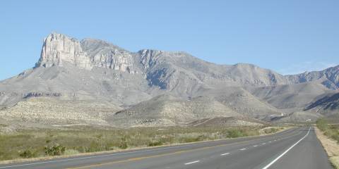
The Guadalupe Mountains rise precipitously from the west Texas plains. The ridge is visible shortly after you leave El Paso eastbound on U.S. highway(s) 62/180. As you swing around the south end of the ridge, the sheer face of El Capitan is quite impressive in front of the taller but gentler Guadalupe Peak. |
|
|
|
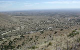
Looking back after the first mile or so up the trail, you can see U.S. 62/180 snaking into this view from the right. The Guadalupe Mountains National Park visitors center is in the lower center and the trailhead at 31° 53.793'N, 104° 49.659'W takes off from the left end of the RV parking area just left of and below center. The area is every bit as desolate as it appears. Although rattlesnakes are supposedly common in this part of Texas, we saw no sign of them during our hike. |
|
|
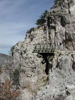
As we approached the final stretch to the summit, we came across a bridge over a narrow ravine. At points near this area, the trail is blasted out of the face of a cliff and the exposure on the downhill side is impressive. It is always a good trail, but if walking along a four foot wide ledge with a couple of hundred feet of air beside you spooks you, these spots will seem a bit dicey.
|
|
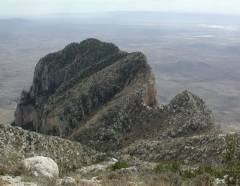
The trail drops perhaps 50 feet after crossing the ridge after the bridge but then quickly makes up the lost altitude. From that part of the trail, the view of the north side of El Capitan shows that it is a rugged outcrop from any direction you might care to approach. Fortunately, the route up Guadalupe Peak is not nearly so threatening. |
|
|
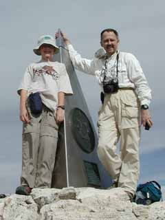
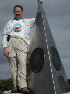
We reached the summit at about 2:20 p.m., just about four-and-a-half hours after leaving the trailhead. Discounting a couple of blister repair and prevention stops and a half-hour break for lunch, it took us about 3-1/2 hours of actual walking to cover the 4.2 miles and 3,000 vertical feet. Not a speed record of any sort, but a good steady pace. The GPS said we had reached 31° 53.480'N, 104° 51.615'W. Interestingly, its estimate of altitude said that we were about 75' above the summit, not at the published 8,749' of the Guadalupe Peak 7.5-minute topo. Of course, we know that the altitude capabilities of GPS systems are limited, so that wasn't too surprising. The stainless steel obelisk at the summit was placed there by American Airlines to commemorate the Butterfield Stage Line which had a station near where the visitors center is. Yes, it's a bit of crass commercialism but it is one of the more unique state highpoint markers. A 50-caliber ammo box houses the summit log, and we signed in, noting TX as my 29th and Nathan's 27th state highpoint. |
|
|
While on the summit, we took our now-traditional panorama of the surrounding area. You will need a Java-enabled browser and the patience to download over a half-meg of data, but you can pan around, up and down in any direction in the image. You don't see the obelisk because Nathan suggested that we position the camera atop it with the tripod legs straddling the faces of the obelisk. The club patch at the nadir is a way of masking the odd-looking pieced-together multiple view of the panorama head which shows up at the bottom edge of the original fisheye views. |
|
|
|
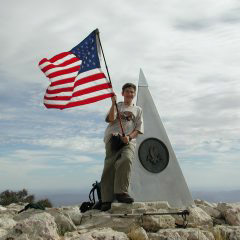
In remembrance of those who lost their lives on September 11, 2001, the Highpointers Club has asked its members to carry a U.S. flag to the summits of the 50 states. We did so and it flew proudly in the stiff breeze atop Guadalupe Peak. |
|
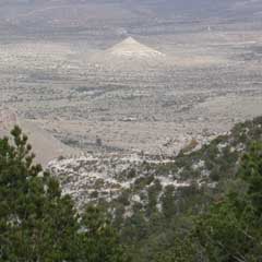
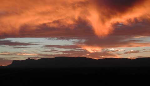
Looking back down the valley toward the trailhead, some of the many switchbacks are evident in the foreground of the shot on the right. There are several conical hills nearby like the one in the background, but according to the USGS topographic map, this particular one is most aptly named "Nipple Hill." We dumped our packs in the car and headed north on U.S. 62/180 towards Carlsbad Caverns. About halfway there, we were treated to the spectacular sunset below. El Capitan is the nearly vertical face at the left edge of the photo. Guadalupe Peak is the prominent peak just to the right of El Capitan. |
|
|
|
|
|
Sunday, 21 October 2001 |
|
Our other destination for this trip was Carlsbad Caverns. We chose to stay in the nearby "Cavern Inn" which is part of a delightfully tacky and touristy set of facilities at the intersection of Hwy 62/180 and the road back into the Carlsbad Caverns National Park. |
|
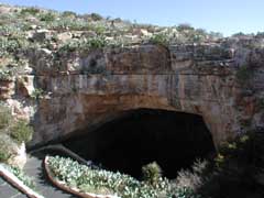 |
From the surface, Carlsbad Caverns appears as this gaping maw leading down nearly 800 feet underground. The tour schedule led us first to take the easy way down using the elevator in the visitors center, to tour the "King's Chamber," one of the large rooms of the caverns. After that, we rode back up and walked down the natural entrance route, following a series of switchbacks down and nearly a mile into the caverns, into the "Big Room." |
|
|
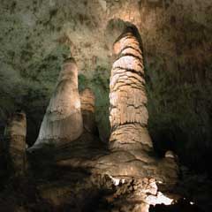
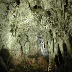
Once into the main part of the caverns, you are presented with a bewildering array of different formations, just a few of which are illustrated here. The trails through the caverns are paved and provided with handrails, prompting the curious to wonder how the caverns might appear without such drastic human intervention. |
|
|
We spent the entire day meandering around underground, fascinated by the many and varied sights. As dinner time approached, we headed north on Hwy 62/180 again into the city of Carlsbad, where we found a Mexican restaurant and watched a baseball playoff game on the big-screen TV as we ate dinner. We returned to our motel to pack and prepare for our return home on Monday. |
||
|
Monday, 22 October 2001 |
|
Our drive back to El Paso was uneventful, but the flight home proved to be interesting. The flight to Dallas left on time and landed about five minutes early. Then we sat on the tarmac for 45 minutes, waiting for a gate to be available. Needless to say, that blew our connection to St. Louis, but there was another flight an hour later with space available. Of course, it took a few trips back and forth between TWA and AA gates to get the cross-booked tickets straightened out, so we barely had time to grab pizzas from the conveniently-located Pizza Hut next to our departure gate before it was time to board the flight home. (In case you haven't flown TWA recently, they have pulled a Southwest move and have stopped meal service on all of their domestic flights. If you want to eat on board, BYO!) We arrived home a bit late but otherwise none the worse for wear. One more state highpoint under our belts...it must be time to start planning the next trip! |
|
Alan Ritter, 25 October 2001 |