|
Lots of Snow to Climb
|
|
Tuesday, May 8, 2018 |

|
After a disappointing year with weather out at Mt. Hood in 2012, I was looking for an opportunity for a repeat attempt at the Oregon state highpoint in 2018. |
|
I had enough frequent-flyer miles on American to snag a free ticket from St. Louis to Portland on Alaska Air. Interestingly, the routing took me via San Diego, so a couple more hours of travel time but when the ticket is free, no complaints. The flights out to PDX were uneventful. I picked up my rental car and drove down to the Best Western at Government Camp, at the base of Mt. Hood. This would be my base of operations for the next few days. |
|
Wednesday, May 9, 2018 |
|
I got up and ate a leisurely breakfast at the motel (included), then headed up to the Wy'East Day Lodge, the ski/climbing headquarters at the Timberline Lodge. Initially, nobody was around the Timberline Mountain Guides office since they were still up on the mountain from the previous night's start. I meandered around, giving myself some time at the 5,900' altitude of the Lodge to start acclimating. When the group came back from the Tuesday/Wednesday climb of Hood, I checked to make sure I knew the right times for the snow training and where to show up on Thursday. The report on conditions on Hood was good and the weather was supposed to be improving after Thursday, so everything was in place. |
|
Thursday, May 10, 2018 |
|
The group met up at 9 a.m. on Thursday for a gear check and snow training. As I figured, all of my gear was fine, but I did need to rent a down jacket from Timberline Mountain Guides for extra warmth while stopped on the upper part of the mountain. Another of those things that isn't really needed in MO, both because of relatively warm winters and the ever-present humidity. TMG takes its clients through an introduction to snow climbing techniques. With my experience on Mt. Ritter, Rainier, etc., this was a refresher for me but much appreciated since opportunities for snow climbing are non-existent in MO, so it's only when I get out west to real mountains that I get any practice. After a couple of hours working on ice axe and crampon skills, we were released to get lunch, dinner and try to grab a few hours' sleep before meeting up again at 1:30 a.m. Friday morning to meet the snow cat and get a ride up to the top of the ski area, cutting several hours off the ascent. |
|
Friday, May 11, 2018 |
|
The group met up promptly at 1:30 Friday morning and boarded the snow cat for the appointed 2:00 a.m. departure. A half-hour or so ride in the snow cat saves several hours of climbing and lets groups summit earlier in the morning. |
|
|
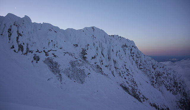
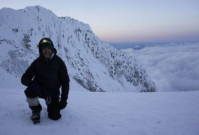
The climb begins with an hour or so on just boots, by headlamp. We were in clouds/fog from the start but climbing by headlamp, weren't missing any scenery along the way. After the first hour, we donned crampons and continued up to the area known as "Devil's Kitchen." There is a steaming lava dome there with the usual volcanic scent of hydrogen sulfide wafting over the area. By the time we got to Devil's Kitchen, the sunrise was pinkening the eastern sky, so a couple of photos were in order. At Devil's Kitchen, we were above 10,000' and looking down on the lower deck of clouds that had the Timberline Lodge area socked in. Above us, the sky was clear and the crescent moon was visible above the nearby ridgeline. |
|
We took a longer break at Devil's Kitchen and stashed our trekking poles there, as the slopes above that point get significantly steeper. Ice axes and roped travel become necessary. The next point of interest is the "Hogsback" ridge, a stretch of snowy ridge that slopes off sharply to both sides as well as sloping up an an increasing angle as you go up-slope. As we approached the the Hogsback ridge, the clouds were closing in again, this time from above. The wind picked up considerably and there was intermittent light snow to make things more interesting. There had been a few inches of fresh snow overnight, as well, but not enough to raise significant risk of avalanche, as the TMG guides verified that the fresh snow had adhered well to the previous layers. Near the top of the Hogsback is a significant bergschrund, or cravasse, where the glacier pulls away from the upper snow. There was a good snow bridge to the right of the 'schrund and Geoff set up a belay a rope's length above the 'schrund to get us safely onto the approach to the "Pearly Gates." Here, the fresh snow was a bit deeper but we could still kick through the soft layer to firmer snow below for good grip with crampons. |
|
|
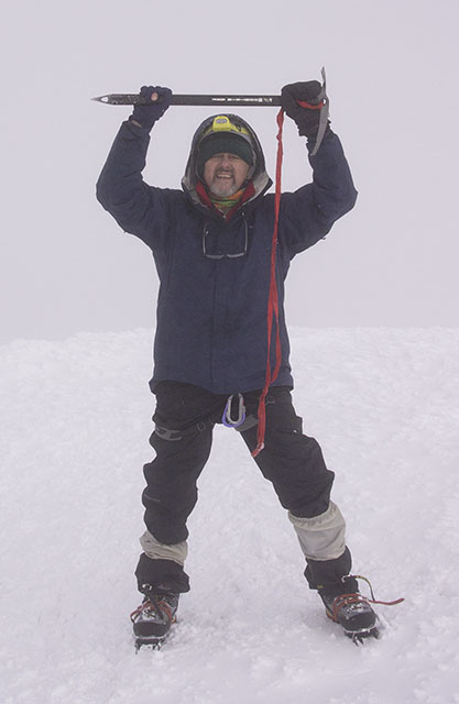
The "Pearly Gates" mark the steepest part of the climb. The Gates, proper, are a pair of narrow chutes cutting through a line of cliffs just below the summit area. Another rope length plus a half in two belays and we had cleared the Pearly Gates. By now, the clouds had closed in and we could see only about 100'. Following the Highpointers' usual advice, "when in doubt, go up," we continued up the last few hundred feet to the summit. By my watch, we reached the summit at 7:35 a.m., almost exactly five hours after the snow cat dropped us at the top of the ski area. There were a couple of other independent climbers already at the summit and the other groups from TMG joined us shortly thereafter, having taken advantage of the belay pickets left in place by our guide for the other TMG groups. |
|
|
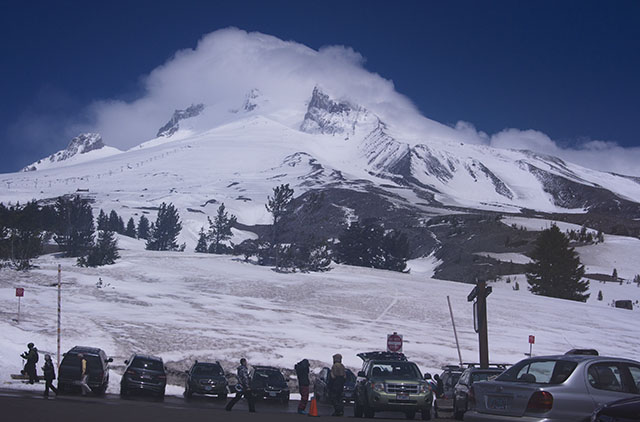
At the summit, proper, there is a reasonable area of more-or-less flat snow where we gathered to celebrate and take summit photos. The guides cautioned everyong not to get too close to the uphill edge of the area, as there is a long dropoff there. The clouds had us socked in but the winds were mild, so we spent about a half-hour on the summit. One of the advantages to being on Mt. Hood is that there is excellent cellular phone coverage, so taking a selfie and posting immediately to Facebook, Instagram, etc., is possible. With state highpoint number 47 in the books, I recalled the other Highpointers' mantra, "the summit is only halfway." Time to carefully downclimb all of those steep bits we had just come up and then walk down the lower slopes back to the Timberline Lodge. The descent took us back through the clouds and snow but this time, we finally got below the cloud deck. At the top of the ski lifts, the sun broke through and, although still very windy, we were no longer in the near-whiteout conditions we had been in from the summit most of the way down. The last couple of miles from the top of the ski lift back to the Timberline Lodge seem interminable, especially where the climbers' trail parallels the boundary of the ski slopes and you watch skiers and snowboarders zipping downhill alongside you. We returned to the Timberline lodge about 12:30, so a bit over 4 hours on the descent. After a quick call home to confirm that we had had a successful and safe climb, I checked the down jacket back in with TMG and headed down to the Best Western for a nap before dinner. The skies above the lodge were blue but Mt. Hood still had its cloud cap as I left for the motel. |
|
|
|
|
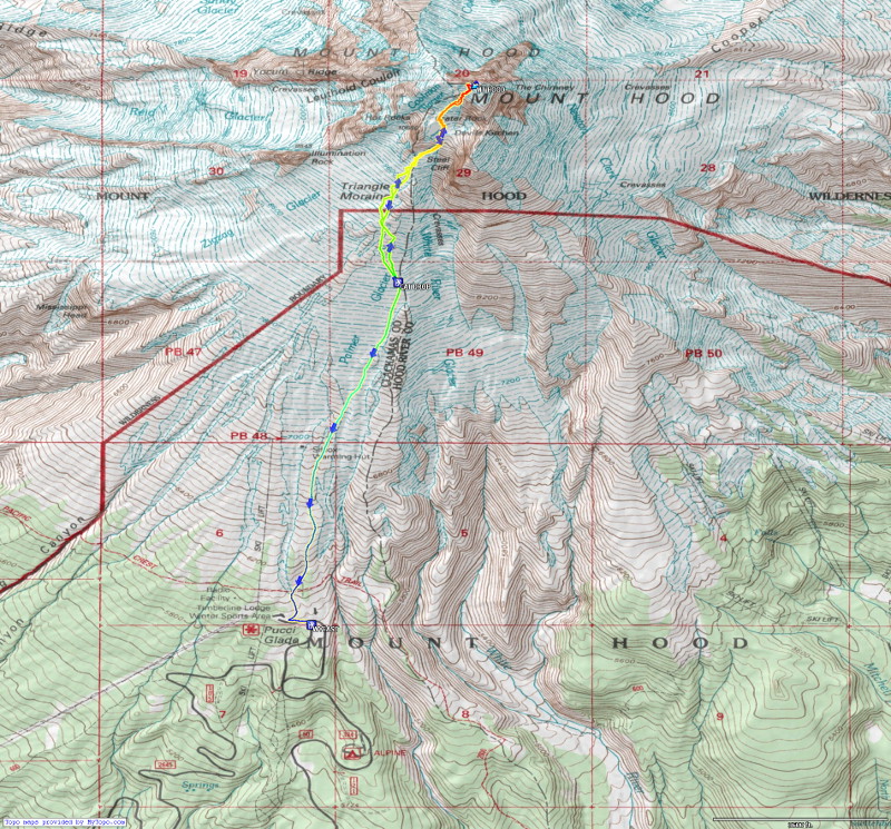
With the overnight start and cloudy conditions, not to mention the steep and exposed climbing, this report isn't as profusely illustrated as some of mine. However, I did have my GPS recording our track up the mountain, starting at the snow cat dropoff point. The small track below links to a much larger copy showing the track laid over the topographic map of Mt. Hood, generated by Topofusion software. |
|
|
|
|
|
Respectfully submitted by
Alan Ritter, May, 2018 |