|
| Massachusetts -- Connecticut -- Rhode Island -- New Jersey -- New York -- Vermont -- New Hampshire -- Maine |
|
Thursday, July 4, 2002 |

|
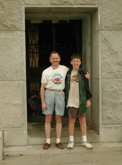
Time once again for our annual highpointing epic. Looking at a map of the U.S., the most tightly-clustered group of highpoints on our "to-do" list was in the New England states. With that in mind, we flew to Boston and drove down to Sturbridge, Massachusetts, on July 4th. We spent the afternoon touring Sturbridge Village (a reconstructed colonial town) before settling down for the night. This year's highpoints would bring on a slightly different range of emotions. As an effort to contribute to memorials for those who lost their lives in the attacks on the World Trade Center and the Pentagon, the Highpointers Club initiated a Fifty Flags project to carry the U.S. flag to each of the fifty state highpoints and document this effort with a poster and scrapbook to include with other memorials on September 11, 2002. Our photo of Nathan atop Guadalupe Peak (Texas) in October, 2001, was featured in the club's announcements about the project, and we had contributed a shot of him at our home state highpoint last December, as well. We therefore carried our flag with us to each of the eight New England highpoints, bringing our contributions to the Fifty Flags project to ten. |
|
Friday, July 5, 2002 |
|
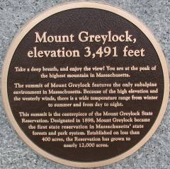
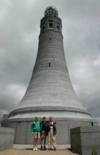
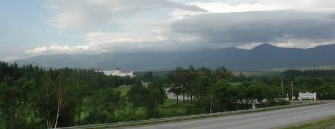
Leaving Sturbridge, we returned to the Massachusetts Turnpike and headed west, turning north on U.S. 20 and then U.S. 7 towards Lanesboro. We turned into Greylock State Park and drove up to the summit of Mount Greylock (3,491'). Located at 42° 38.236'N, 73° 9.997'W, the summit is topped by an impressive war memorial tower. There is a CCC-era lodge adjacent to the parking lot and we tried the snack bar for lunch. Not one of our better decisions...the food was overcooked to the point of carbonization, so you would be well-advised to leave the park and find a restaurant elsewhere should you find yourself atop Mount Greylock at meal time. |
|
|
Click here for a 360-panorama shot at the overlook adjacent to the War Memorial monument. Note that the pan is a 600kbyte file, so a broadband hookup or a lot of patience on a dialup line is required to view it. (No special software is required, just a Java-enabled browser. Also, for some reason, Netscape's Java implementation doesn't clean up its RAM allocation, so if you try to view several of these pans, you may get an "out of memory" error from the Java interpreter and the pan won't load.) |
|
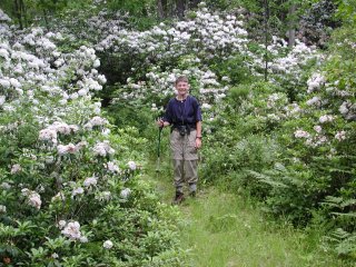
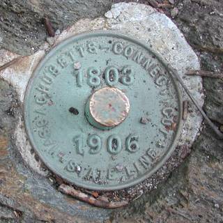
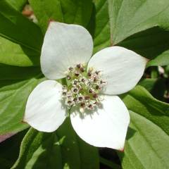
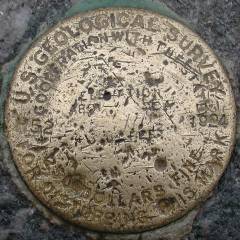
We headed south from Mt. Greylock, back down U.S. 7 to U.S. 44 into Salisbury, CT. From there, you follow a series of dirt roads to the trailhead for Mt. Frissell. Although the summit of Mt. Frissell is actually in Massachusetts, the Connecticut highpoint is on the southern slope, where the summit ridge crosses the Massachusetts / Connecticut state line. The Mountain Laurel (Kalmia Latifolia), appropriately the state flower of Connecticut, were in bloom along the lower stretches of the woodsy trail. The hike to the summit of Mt. Frissell (2,453') and then down (down?) to the Connecticut highpoint (2,380') is only a little over a mile. The highpoint is marked with a state boundary survey benchmark at 42° 2.982'N, 73° 28.990'W and a cairn, although the cairn is clearly on the Massachusetts side of the state line. The view from the highpoint is obscured by brush on the ridge, so I shot my summit panorama (850k file) from a slightly better vantage point a hundred yards or so back along the trail, where there is a nice rock outcrop that opens out the view quite nicely. |
|
|
|
|
Saturday, July 6, 2002 |
|
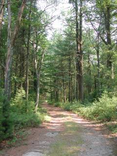
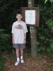
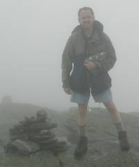
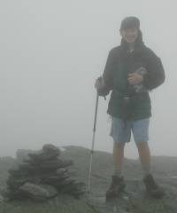
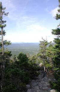
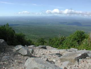
Leaving civilization behind in East Hartford, we headed east along I-84 to West Wilmington and took state route 74 to U.S. 44 in West Ashford and state route 101 a couple of miles across the CT/RI border and into the wilds of Rhode Island. Ok, just kidding...Jerimoth Hill is not exactly a wilderness area. The trick involved is that access to it requires crossing a hundred yards of jealously-guarded private property. Fortunately, the Highpointers Club has negotiated a limited number of open-access dates with the land owner, so we synchronized our travels for this trip with the July 6, 2002, open date. (See the Club web site for a list of other open dates and please cooperate by using one of these dates so the land owner continues to allow the controlled access and doesn't shut us down completely.) The highpoint, proper, is located at 41° 50.953'N, 71° 46.790'W on property owned by Brown University. A clearing adjacent to the summit has several sheds housing telescopes. The driveway leads to the clearing, with the summit boulder in the woods at the near edge of the clearing. The summit panorama (824k file) is uninspired by breathtaking view standards but clearly shows just how woodsy the tallest hill in Rhode Island really is. |
|
|
|
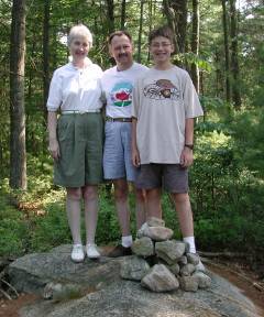
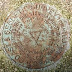
With several other highpointers around, we shared photo duties and swapped highpointing tales with our fellow journeyers. Nearby, but not on the summit, are three USGS benchmarks. We managed to find the two close to the access road but the third is a bit off the beaten path and may have been covered with leaves, so we didn't waste much time searching for it. At the end of the driveway on state route 101, there is a sign noting the private nature of access to the highpoint. On non-open-access dates, this sign is recognized by the Club as having visited the Rhode Island highpoint. "Close enough" in this case is almost certainly adequate and helps ensure that the landowner's property rights are respected by Club visitors. |
|
|
|
|
|
|
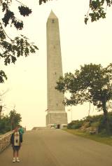
Leaving Jerimoth Hill and Rhode Island behind us, we retraced our steps to I-84 and headed west across Connecticut, the tip of New York and across into New Jersey, where we turned south on state route 23 to the aptly-named "High Point State Park." Funny, that's the name of the highpoint, too...High Point! A short walk up a paved road takes you to the summit obelisk, masquerading as the Washington Monument in miniature. The state has apparently run out of funds in mid-restoration, since the inner stairs have been removed but never reinstalled and the bronze door (reportedly stolen for scrap metal value) has likewise not been replaced. Nonetheless, we recorded a waypoint at 41° 19.233'N, 74°39.717'W and took our summit photos. The yellow cast to the photo on the left is actually quite close to the light that day. Smoke from forest fires in Quebec was being blown down over New York and New Jersey that day and it cast a pall that greatly limited visibility from the summit and reduced the sun to a sunset orange ball even at midday. |
|
|
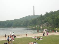
While researching the trip, I had noted this lake on the topo quad in the High Point State Park. We may all have our eponymous peak in the Sierra Nevada, but now my wife has her own Lake Marcia. Interesting trivia you discover while highpointing! |
|
|
From the High Point state park, we resumed our trek northward through New York, taking I-87 north and I-88 west to Oneonta where we settled down for the night close to Cooperstown. |
||
|
Sunday/Monday, July 7/8, 2002 |
|
Our planned break in the trip was to spend a half day at the Baseball Hall of Fame in Cooperstown, NY. If you're a baseball fan, this is a must-see locale. If you're not into baseball, it's worth skipping. For Nathan, this year was particularly appropriate, since he is a big fan of Ozzie Smith, the long-time Cardinals shortstop who was the only modern player inducted into the Hall of Fame in 2002. From Cooperstown, we made our way back to I-87 north to Witherbee and then northwest on state route 73 to the Adirondack Loj, near Lake Placid, NY. Marcia dropped Nathan and me off at the trailhead and continued on to more civilized accommodations in Lake Placid. |
|

|
|
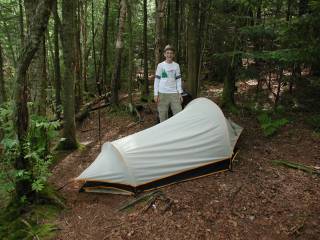
Mt. Marcy is a 15-plus mile round-trip hike via the Van Hoevenberg trail. Although that is theoretically within our day-hike range, neither of us felt particularly inspired to push hard enough to do it in one day, so we planned a one-night overnight. We hiked in about four miles, a couple of miles past the popular campsites at Marcy Dam but before the point of closure to camping at the 3,500' level along the trail. That gave us a nice head start for the summit the next morning and was an excuse to haul our backpacking gear along on this trip. |
|
|
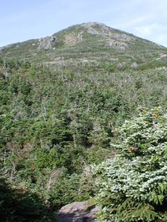
The trail meanders through mixed forests and into a subalpine forest of spruce and other conifers as you get above 4,000'. The few glades and meadows are protected against foot traffic by boardwalks for hikers making their way to the top of New York state. |
|
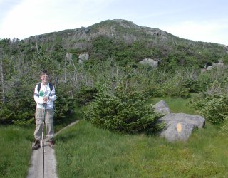
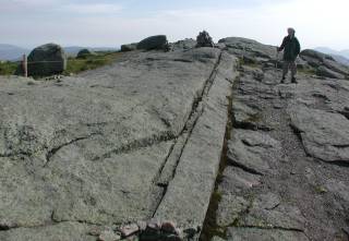
Ultimately, you leave even the scrub spruce and ascend to this rocky granite ridge. There are a few fairly steep spots, but nothing requiring use of hands to ascend. The roped-off areas are being allowed to regrow their alpine vegetation, protecting local endangered plant species. Up on the exposed summit ridge, the winds picked up and the temperature dropped enough that a wind shell over summer hiking clothes was greatly appreciated. |
|
|
|
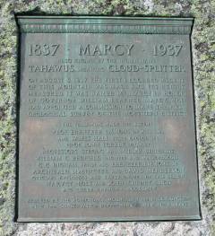
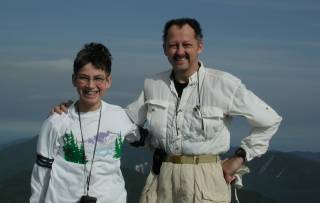
We made good time and arrived at the summit at 44° 6.771'N, 73° 55.451'W in time to greet a couple of other groups of hikers approaching from various other trails in the area. We took our requisite summit photo and a photo of the plaque commerating the first recorded climb(?) of Mt. Marcy by white men in 1837.
|
|
The view from the top of Mt. Marcy lends itself a bit better to taking a good panorama. (578k file) The High Peaks region of the Adirondacks is spread out all around you and the clear weather contributed to a better view. A bit of highpointing trivia: Theodore Roosevelt was on Mt. Marcy when William McKinley was assassinated and TR learned that he was President of the United States. Speaking of highpointing trivia, did you know that Mt. McKinley (highpoint of Alaska, the U.S. and the North American continent) was not named after President McKinley? In fact, it was named after Secretary of the Interior McKinley, before he was elected President. |
|
|
|
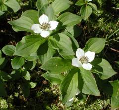
In sheltered, slightly damp locations along the trail we observed large numbers of these wildflowers. Known by common names like "bunchberry" or "ground dogwood", they are properly called cornus canadensis and are common throughout New England. |
|
|
After breaking camp, we headed back toward the trailhead, pausing briefly at Marcy Dam. Although the dam is clearly named on the topo, the lake is not, so whether it is "Marcy Lake" or something else entirely is beyond me. This is a very popular spot to camp along the trail, even though it is a short two-mile hike from the trailhead. As a result, the bears know there are easy pickins around and frequent the campsites. A bear line is strung across the river below the dam and hikers are encouraged to use it. Some unconfirmed reports indicated that mother bears will send cubs scurrying out paw-over-paw, hanging from the bear line, to bite the bags off the steel cable. Since we were using my bear can, and were camped much farther up the trail, we had no visitors by day or night. |
|
|
|
|
|
Marcia met us back at the trailhead and we headed east toward Vermont and our next destination, Mount Mansfield, staying in Stowe for the night. |
|
|
Tuesday, July 9, 2002 |
|
|
When we awoke the next morning, it was mostly sunny but Mount Mansfield, like most of the surrounding peaks, was shrouded in clouds. We paid our entry fee and drove up the auto access road to the top parking lot, about a mile-and-a-half from the true summit. From there, we followed the well-blazed trail through the clouds and light drizzle ("falling" horizontally in a stiff breeze) to the "chin" of the mountain which is said to resemble a face in profile. It may do so, but we certainly could not attest to the veracity of that, given the extremely limited visibility. |
|
|
In addition to the cairn visible next to us in the photos above, there is a very worn benchmark at the summit of Mount Mansfield, 44° 32.639'N, 72° 48.888'W. Rapidly becoming as damp as the surrounding terrain, we beat a quick retreat to the car and drove back down the access road. Our route from Vermont into New Hampshire took us conveniently close to the Ben and Jerry's ice cream factory, so we made our lunch stop there and enjoyed special treats for dessert. Continuing across into New Hampshire, we approached Mount Washington and its cog railway in time to catch the last train of the afternoon. |
|
|
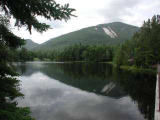
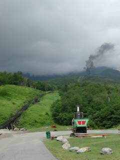
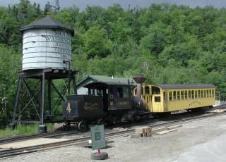
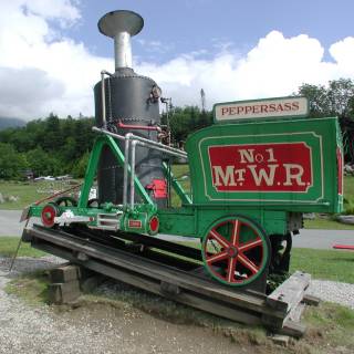
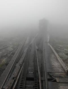
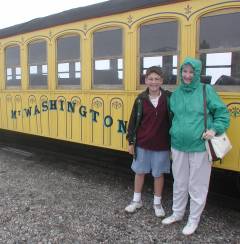
When we arrived at the cog railway station, the previous train was perhaps halfway up Mt. Washington, clearly marked by its plume of black coal smoke. There are seven operational trains, each consisting of a steam engine and a single passenger car operated in a pusher fashion. In addition to the "modern" engines, there are several display pieces including this first Mount Washington Cog Railway engine, which lacked even the amenities of an enclosed cab for the engineer and fireman. Be forewarned that, although convenient, the cog railway is not an inexpensive way to ascend Mount Washington. Normal adult tickets are $50.00 each, but if you take the last train of the day, the second and successive members of the party pay a discounted $39.00 each. Being a railroad buff anyway, I opted to pay the freight rather than risk burning out the transmission in the rental car by driving to the top of the mountain. Given the historic nature of the cog railway, I figure it was an investment in a living history lesson as well as an enjoyable means of attaining the summit. |
|
|
|
|
|
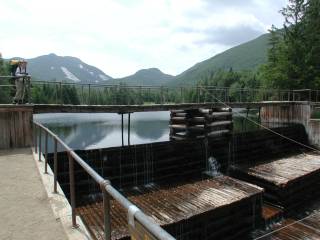
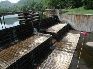
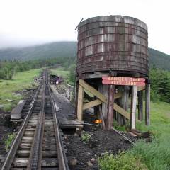
As you ride up the mountain, the train pauses once to refill its water supply from this tank along the track. According to the brakeman/narrator, the train consumes about one ton of coal per trip to the summit, all of it shoveled by hand by the fireman. |
|
|
|
Shortly above the water tank is one of the two turnoffs where the upbound and returning trains pass. As you can see in this photo, the downhill train stops, switches over to the turnout and waits for the uphill train. One of the incidental advantages of being on the last train of the day is that there are no such pauses on the way back down the mountain. |
|
|
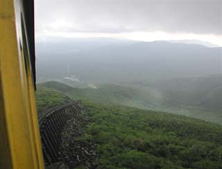
By the time we reached the second turnout, the track was shrouded in clouds so thick you could barely see the downhill train over on its siding. From information in the visitors center at the summit, this is the normal condition of Mount Washington. A clear day on the summit is the exception rather than the rule. Mount Washington is also the site of some of the worst weather anywhere. According to the state of New Hampshire's website,
|
|
|
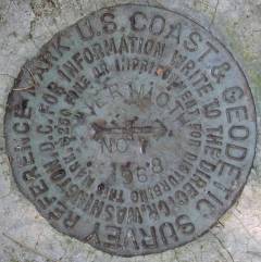
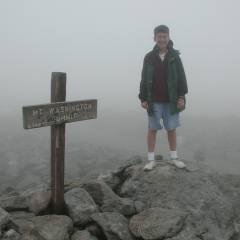
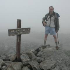
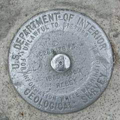
When the train arrived at the summit, Marcia made a beeline for the visitors center and shelter while Nathan and I sought out the summit sign and benchmark at 44° 16.233'N, 71°18.283'W. Temperatures were well down into the 50s and the wind was strong, but not as strong as it might have been. We didn't tarry long after taking our summit photos! |
|
|
Shortly before the train was to leave, Marcia came out for just long enough to pose with the train near the visitors center. She quickly ducked into the car in anticipation of the return to warmer climes at the bottom of the mountain. |
|
|
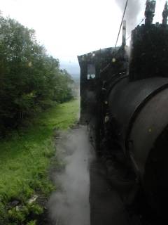
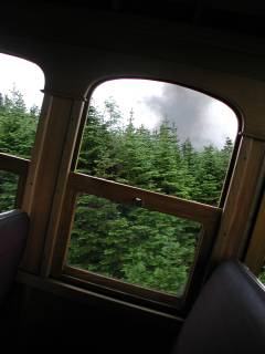
About two thirds of the way up the mountain, there is an impressive trestle referred to as "Jacob's Ladder." this is also one of the steepest spots on the railway as evidenced by the photo through a window of the car, below. Yes, the camera really is being held level. Look at the tops of the trees for a true vertical reference! |
|
|
|
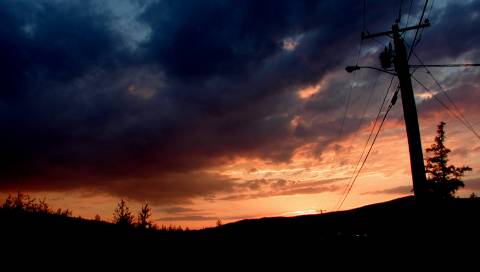
We stayed near Mount Washington that night and were treated to a spectacular sunset as we came out of the restaurant after dinner. |
|
|
|
Wednesday, July 10, 2002 |
|
|
|
We awoke to the same sort of partly-cloudy skies that we had experienced the day before, vindicating our decision to go ahead and ride the last train of the day up Mount Washington. Looking past the 1902-vintage Mount Washington Hotel and Resort (definitely in the premium price range!), the mountain was once again cloud-shrouded at its summit. Wednesday would be a travel day as we meandered through the backroads of Maine and up to Millinocket, the jumping-off point for Mount Katahdin, the eighth and last planned highpoint of this trip. |
|
Thursday, July 11, 2002 |
|
Researching this trip, I had read many horror stories about people having to line up in the middle of the night to gain access to Baxter State Park and the trailheads for Mount Katahdin. Fortunately, we ran into several hikers at the Katahdin Inn Motel in Millinocket who said that mid-week access was no problem. As a result, Nathan and I slept "late" until 5:30 when the continental breakfast opened up at the motel, grabbed our breakfasts and ate in the car as we drove to Baxter State Park. The parking lot at the Abol Creek trailhead (45° 52.434'N, 68° 57.868'W) was less than half full when we arrived. We parked, signed in at the ranger station there, hoisted our day packs onto our backs and set off toward the summit of Mount Katahdin. |
|
|
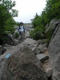
The Hunt, or Appalachian, trail is the more common approach up Katahdin from the west side. However, it is over a mile longer each way and I had decided that the steeper Abol trail would be interesting to try. It is a bit less than 4 miles out, and 4,000' up to the summit. What that observation does not say is that 2,500' of that 4,000' is climbed in the middle one mile of the trail! It starts out deceptively enough, meandering gently upward through the trees but after a mile or so, breaks out into a rockslide chute that rapidly turns steeper. Holmes lists the Abol Trail as "on trail" but acknowledges that it is a strenuous second-class climb. Although thoroughly blazed with blue paint on the rocks, I hesitate to call this a "trail." There is nothing particularly threatening about even the steepest parts, but it definitely is a strenuous scramble up alternating stretches of talus and scree interspersed with desk-sized to car-sized boulders. |
|
|
|
|
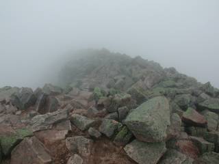
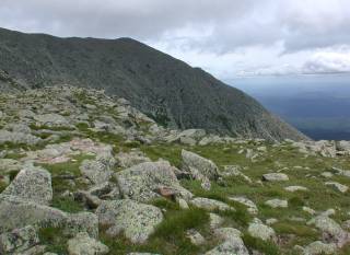
Once we reached the ridge, we were very glad that we had taken the more difficult route. The wind was howling out of the northwest and anyone hiking up the Hunt trail would have been exposed to that wind nearly their whole trip up the mountain. We hunkered down briefly in the lee of a rock wall constructed by campers over the years, donned our fleece and Gore-Tex parkas and continued along the ridge toward the summit. Clouds would intermittently drift over the ridge, but the summit was continuously socked in as we approached. |
||
|
|
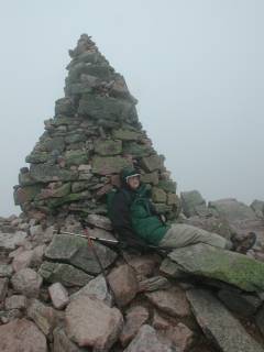
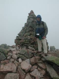
By the time we reached the summit, Nathan was pooped from fighting the 40 MPH winds and zonked out in the shelter of the summit cairn while I set up for our summit photos. The official altitude of the summit (45° 54.265'N, 68° 55.315'W) is 5,268' but the wags who built the 12' cairn now claim it is one mile high. There is no benchmark at the summit, proper, although we did spot one along the ridge before we started up the last fairly steep pitch to the summit. |
|
|
Fortunately, no one was around to notice my contraband electronic device as I recorded a GPS waypoint at the summit. The powers-that-be at Baxter State Park take a dim view of all things electronic, but I hardly think my momentary use of a silent radio receiver destroyed the wilderness experience for the granite boulders at the summit. |
||
|
I had originally hoped to find another highpointer who would be doing Katahdin the same day as we were in order to spot a car at the Roaring Brook trailhead. We would have then continued east across the Knife Edge and down the Chimney Pond trail. This would (in theory) have afforded us some different views on our way down. However, given the temperatures in the 40s, winds of 40 MPH and the damp clouds blowing over, we were just as glad not to have to traverse the Knife Edge that day. |
|
|
|
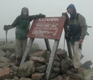
As we left the summit and headed back toward the Abol Trail fork, we encountered a couple of other hikers and exchanged photo duties at the sign marking the northern terminus of the Appalachian Trail. I asked Nathan whether he would like for me to drive down to Georgia and meet him at the other end, but he declined the invitation at least for the moment. |
|
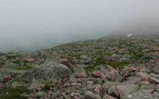
The clouds lifted briefly on the upper part of the summit ridge and we were able to see far enough over the steep southern face of Mount Katahdin to spot a lingering patch of snow left over from the winter. Having seen snow in the summer around the Rockies and Sierra, but above 10,000', it was interesting to see that any would still be left at only 4,500' or so by July. |
|
|
|
As we continued back down the summit ridge, we paused briefly to take a photo of this plaque and the benchmark we had spotted on our way up. |
|
|
|
When I looked up from taking the photo of the benchmark, the clouds actually lifted completely off the summit and I wished (fleetingly) that our timing had been just a bit different. However, the clearing was momentary at best and within a minute or two, the clouds had once again descended and blotted out the upper few hundred feet of the mountain. As we made our way along the ridge, we encountered a steady stream of hikers coming up the Hunt trail. Amazingly (well maybe not), many of them were clad in shorts and t-shirts with no evidence of foul-weather gear or even adequate water for a four or five hour hike. One wonders why did they look a bit like fresh-frozen hiker-cicles? |
|
We spotted the blue blazes marking the Abol Trail as it branches off from the white-blazed Hunt Trail and paused long enough to take one last panorama. (755k file) before we made our way to the edge of the ridge. The scramble back down the rockslide chute was, if anything, more "interesting" than the scramble up, but we made it without incident and arrived back at the car in the same number of pieces as we started. Eight highpoints attempted, eight completed. A very successful trip! We celebrated the accomplishment with dinner at the "River Driver" restaurant a few miles east of Millinocket. Not inexpensive, but definitely worth the drive and a great place to relax and enjoy a good dinner at the end of the highpointing portion of the trip. |
|
Friday-Sunday, July 12-14, 2002 |
|
When we awoke Friday morning, the sky was hazy and we could distinctly smell the smoke of the Quebec forest fires. We pointed the car east toward Medway, Maine and I-95. A couple of detours along the way, one to visit some friends who summer in Maine and another (at Marcia's request) to see ex-President Bush's compound in Kennebunkport, and it was dinnertime by the time we arrived at our Marriott Courtyard in Lowell, Massachusetts. (I had stayed there on business trips several times, knew the area. Even though it's a bit far from town, it is convenient to the major highways and isn't usually busy on weekends.) Saturday, I gave Nathan a tour of the MIT campus (had to show him where he will be going to college!) and we walked a good portion of the Freedom Trail in near-90-degree heat. (Where was that wind and cool weather from Katahdin now???) We ate dinner with some fellow MIT alumni near Boston, packed up and got ready for our flight home on Sunday. When we turned the car in, we had covered just over 2,000 miles in our eight-state marathon. The flight home was uneventful as we updated our tallies of state highpoints. Marcia has done 19, Nathan has done 35 and I have now done 37 of the 50. Nathan and I are done with everything east of the Mississippi and I'm done with everything east of the Rockies except Oklahoma. (Nathan will have to go back someday and do the Dakotas since he was prevented from doing SD by the rainy weather and pooped out in the heat in ND.) |
|
Respectfully submitted by
Alan Ritter, August 2002 |