|
Fifty/Fifty: Success on Borah,
|
|
Sunday - Wednesday, August 4-7, 2013 |

|
After a disappointing year with weather out at Mt. Hood in 2012, I was looking for an opportunity to pick up a couple more state highpoints in 2013. Having recently retired, I could be more flexible and found another highpointer with plans for Borah Peak in Idaho and Kings Peak in Utah that meshed well with my schedule for the late summer. |
|
I opted to drive out and headed west from St. Louis on Sunday and up through Nebraska. On Monday, I passed through Kimball, near Panorama Point and drove down to revisit the Nebraska state highpoint that we had done on our swing through the upper Midwest in 1998. The highpoint hasn't changed appreciably since then but there is a new visitor's center near the Kimball exit from I-80 and they do provide detailed maps of how to get down to the highpoint from the Interstate. The day was somewhat threatening with scattered showers around as I drove down to the highpoint but it cleared a bit after I got there so I was able to shoot a summit panorama. After a night in Kimball and another in Evanston, WY, I headed on to Salt Lake City on Wednesday to meet my fellow climber for the week, Dorothy Kucar, who had flown in from New York. We drove up through Mackay, Idaho and set up our tents at the camping area at the Borah Peak trailhead. It is a dry camp, so be sure to bring enough water for both the evening and the next day's climb. |
|
|
Thursday, August 8, 2013 |
|
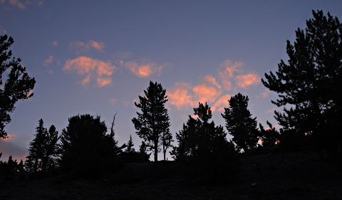
My alarm went off at 4:00 a.m. After a quick cold breakfast and a check of our packs for the day, we set off from the trailhead by headlamp at 5:00 a.m. The first mile or so of the climb is up an unrelentingly steep trail that takes you from the trailhead at 7,600' to the beginning of the ridge at about 9,800'. Near 6:00 a.m., we topped out onto the ridge as the impending sunrise tinted the few scattered clouds pink behind the last of the trees along the beginning of the ridge. We were soon joined by a couple of other groups of climbers. It was a fairly crowded day by Borah Peak standards but we were glad for the company and exchange of route-finding thoughts a bit later in the climb. |
|
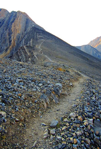
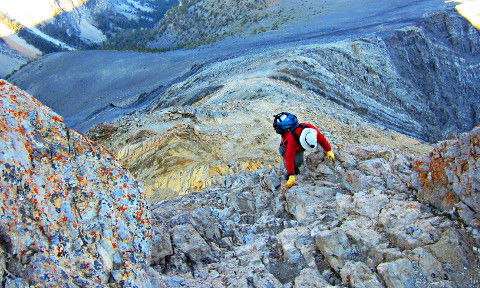
Photo courtesy Dorothy Kucar |
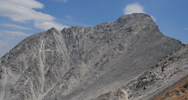
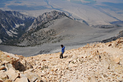
Once you reach the ridge, the slope moderates greatly for the next half-mile or so. The trail along the ridge is easily followed and not exposed save for a few spots where it skirts the edge of the ridge. The dropoff to the left of the ridge is nearly vertical and goes down at least 1,500' to the bottom of the valley below. The trail steepens again as you approach the aptly-named Chicken-Out Ridge, visible in the upper-left corner of this photo. The band of lighter brown rock between the two bands of dark rock marks the beginning of Chicken-Out Ridge, proper. Once you reach that point, the hike turns into a climb with some very exposed third-class scrambling up to and along Chicken-Out Ridge. Initially, we stayed to climber's right on the approach to Chicken-Out Ridge but in that band of lighter rock, crossed over to climber's left, staying near but not on the top of Chicken-Out Ridge.
Photo courtesy Dorothy Kucar |
|
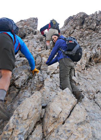
At this point, another group of three climbers caught up with us. We exchanged comments about the route and swapped leads a couple of times as one of us or the other found the preferable route along Chicken-Out Ridge. For the most part, holds are plentiful and evident but there were a couple of spots where what holds there were became sketchy and/or loose so it pays to test each hold before depending on it, especially given the 1,500' or greater exposure should you fall. Yes, I did say that Chicken-Out Ridge is aptly named!
|
|
Once you get to the end of Chicken-Out Ridge, you are faced with a final challenge. This steep downclimb often ends on a ridge of snow but by August, the snow had melted out and the ridge was gravelly and narrow but not a problem. The downclimb is shorter when there is snow, and the added six feet or so was one of the more "interesting" bits of the downclimb since holds there are sketchy and you wouldn't want to drop to the ridge and slide off to either side, as it is steep enough both ways that stopping a fall would be difficult. We made the downclimb without incident and from there, a good use trail reappears, leading to the summit. The following two shots illustrate that part of the trail from different viewpoints. |
|
|
|
|
|
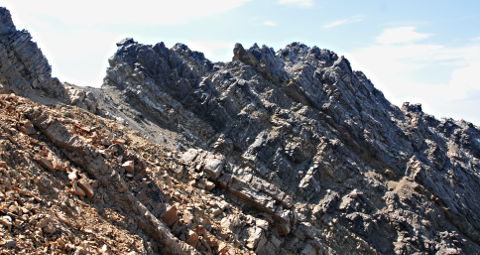
The photo above, shot from our descent, shows most of the trail from the end of Chicken-Out Ridge up to the final pitch toward the summit of Borah Peak. The trail is well-used and clearly visible as you cross the snow or gravel ridge after the downclimb from Chicken-Out Ridge. Part of Chicken-Out Ridge is visible as the dark ridge in the upper center of the photo. The trail contours around the first hump and then follows another short ridgeline before heading up the final stretch to the summit. The photo below shows the summit ridge and the trail after that final ridge traverse. From the last bit of ridge, the trail heads up, turning a bit to the right and sharply upward the last couple of hundred feet to the summit ridge, arriving on the summit ridge in the notch just to the left of the summit, proper. The page linked to in the photos includes marked versions of both photos indicating where the trail is. It is a bit faint in the second photo but is quite clear when walking the trail up from the end of Chicken-Out Ridge. Only the last little bit is quite steep but it still is a decent use trail and only second-class scrambling for that final climb to the summit ridge. |
|
|
|
|
|
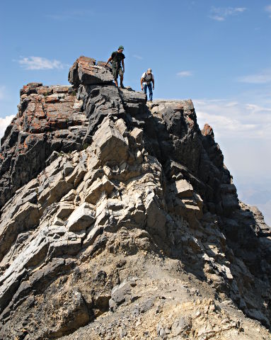
Photo courtesy Dorothy Kucar |
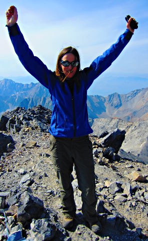
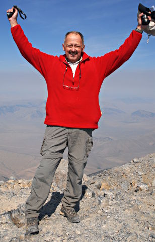
In this case, the third time proved the charm and we arrived at the summit of Borah Peak at 10:30 a.m. under a sunny blue sky. We shared summit photo duties, the other, faster, group having already started down by the time we got to the summit, proper. We signed the summit register (a new notebook would be useful as we had to find spare corners to sign, the book being out of empty pages.) I shot my usual summit panorama and, with the first hints of clouds starting to build, we headed back down the trail toward Chicken-Out Ridge. State highpoint number 44 for me, number 40 for Dorothy. |
|
|
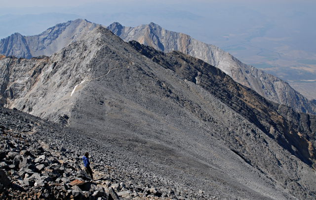
Photo courtesy Dorothy Kucar |
|
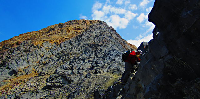
The return along Chicken-Out Ridge is marginally easier than the ascent but only because you know you have made it through those bits once already. As usual on descent, we were being even more careful, knowing we were tired from the climb up. We followed roughly the same route back as we had done coming up, going up the "step" from the gravel ridge to the top of Chicken-Out Ridge and then downclimbing a bit to pick up some bits of a use trail that fades in and out on the side of the ridge perhaps 15-20 feet below the ridge, proper. Dorothy's photo of me gives some appreciation of the sketchier parts of the traverse. Realizing there is another 1,500' or so of similar or steeper drops below my feet shows that due caution is advised. |
|
|
When you start to see the lighter beige rocks as in this photo of Dorothy, you know you are approaching the end of Chicken-Out Ridge on descent. In this area, the climbing starts to get easier but the footing is often loose in the patches of gravel and scree. Looking ahead and down, you can also see the gravel road leading from the highway to the trailhead. As you approach the nose of the ridge, you can see the parking area looking tantalizingly close but this illusion soon fades as you realize you still have a mile or more of steep trail to contend with before you reach the car. |
|
The clouds began building in earnest as we walked back down the ridge toward that last steep descent to the trailhead. There were a few light rain showers and an occasional distant peal of thunder, so we were glad we had opted for a very early start in order to be off the summit and back down beyond Chicken-Out Ridge before any serious weather developed. Our pace slowed quite a bit on the steep downhill trail from the end of the ridge back to the trailhead. We returned to the trailhead at 3:40 p.m., almost nine hours after starting up. After an hour's rest, we packed up camp and headed to Evanston, Wyoming, for the night. |
|
Friday - Saturday, August 9-10, 2013 |
|
With the harder peak behind us, we looked forward to the hike into Kings Peak. Trusting a bit too much to my Garmin car GPS, we ended up too far south of Mountain View, WY, before I realized that the route finding algorithm in the Nuvi 1490 wanted us to drive off on some roads conspicuously marked "Private. No Trespassing." We backtracked to Mountain View and asked the ranger for the preferred route down to the Henrys Fork trailhead. (Hint: Turn right at the statue of a moose in Mountain View.) Eventually, the GPS stopped trying to turn us around and agreed with the correct route but we wasted the better part of an hour believing its initial routing. No matter, as we had plenty of time to make it up to Dollar Lake and set up camp for the night. There was intermittent rain but it stopped before we got to Dollar Lake. The very good news about the trail is that sections of boardwalk have been installed through the willow swamp that was such a pain on my two previous trips to Kings Peak. This year, we were there late enough in the season that the swamp was mostly dry but any time earlier in the season when the snow melt is in process, the boardwalks will save at least a half-hour and possibly as much as an hour of slogging and picking your way through the willow thickets and horse-cut knee-deep muck in the swamp. I once again set my alarm for 4:00 a.m. and woke to a mostly-starry sky. Unfortunately, by the time we had eaten breakfast and started up the trail toward Gunsight Pass, the skies had clouded over and we were concerned about a repeat of the previous day's thunderstorms. We opted to head back to the tents and catch a few extra winks to see if conditions improved. They remained marginal and we decided to bail out and head back to Henrys Fork. While there might have been enough of a window to get to the summit and at least back to Anderson Pass, the winds were strong and it would have been a difficult climb up the ridge to the summit of Kings Peak. Stormed off (well, threatened off, at least) again, we will have to return to Kings Peak at least one more time. The trail from Henrys Fork up to Dollar Lake is an easy (but uphill) hike through a beautiful area, so we won't mind having to return. We drove down to Sandy, Utah, where Dorothy has friends who graciously hosted us Saturday night. |
|
Sunday - Tuesday, August 11-13, 2013 |
|
|
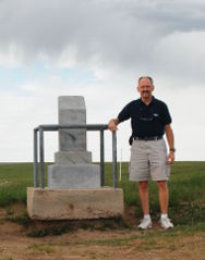
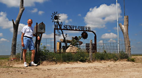
After consulting my GPS and Google Maps, I found that returning through Colorado and Kansas would only be about 50 miles longer than the more-direct route of I-80 back across Nebraska and down to Kasas City, MO. Having friends in Erie, CO, whom I don't get to see very often made up my mind and I changed my return route accordingly. Mount Sunflower had been our first highpoint back in 1995 so when I got to the Kanorado exit on I-70, I once again headed south on the gravel section roads to revisit Mt. Sunflower. The summit decorations have changed a bit since we were first there and there is now a nice shelter providing a shady spot with a picnic table which I used to enjoy a quick lunch before driving back north to I-70 and heading east toward St. Louis. |
|
One more night on the road in Salina, KS, and I got home on Tuesday, August 13. Somewhat over 3,800 miles on the Outback and a truly tough highpoint checked off. Any trip where you return in the same number of pieces as you started counts as a success and being able to summit Borah Peak added to the satisfaction. Kings Peak will wait for another trip... |
|
|
Respectfully submitted by
Alan Ritter, August, 2013 |