|
Oklahoma/New Mexico/Colorado:
|
| Oklahoma -- New Mexico -- Colorado |
|
Saturday, August 9, 2003 |

|
Another year, another highpointing epic. With nearly everything east of the Rockies already under our belts, clusters of highpoints are few and far between. After a bit of head-scratching over highway maps, we had planned on a three-state loop, flying to Denver and picking up the highpoints of Oklahoma, New Mexico and Colorado from there. It seemed sensible to do the three in order of ascending altitude, so from Denver, we drove down to Clayton, NM, stopping briefly at the Capulin Volcano National Monument in northeastern New Mexico. Capulin is a typical cinder cone that has been around long enough to collect a nice covering of scrub, stabilizing its slopes and maintaining its classic profile. |
|
Sunday, August 10, 2003 |
|
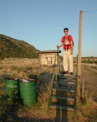
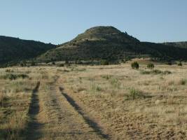
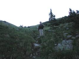
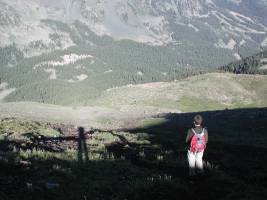
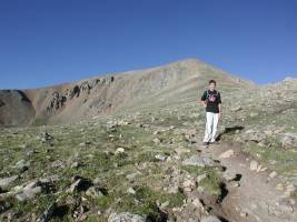
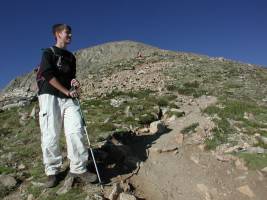
Knowing it would be very hot if we waited long after sunrise, Nathan and I got up at 4:00 a.m. and drove over into the panhandle of Oklahoma. The highpoint is a few miles from the thriving metropolis of Kenton (don't blink). The trail begins at 36°57.427'N, 102°57.408'W with a climb over a stile. It then follows a jeep trail as it meanders around the perimeter of Black Mesa for a mile or two before heading up the slopes of the mesa. |
|
|
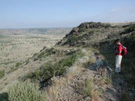
The only steep part of the trail snakes up the side of Black Mesa. Given the relatively low altitude, even this isn't a particularly tough pitch, but we were happy to be doing it before the temperature rose with the morning sun. The trail itself is obvious and easily followed, with periodic green metal arrows pointing the way. Originally, these were labelled with red lettering noting that they point to the Black Mesa summit, but most of the red paint has succumbed to the elements, leaving the arrows to indicate direction, but knowledge of the destination is left as an exercise for the reader. |
|
|
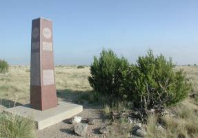
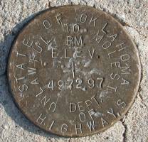
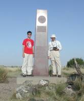
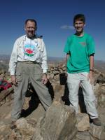
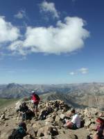
As you crest the rise, the jeep trail narrows to a footpath. The summit marker lies the better part of a mile west on top of the mesa, but it would take a surveyor to determine that it is indeed placed at the highest point of the mesa, which is basically as level as a pool table out to where the edge drops off in each direction. The summit, proper, is marked with a granite obelisk at 36°55.911'N, 102°59.842'W. A summit log may be found in an ammo case on the base of the monument. Not surprisingly, we were the first up that day. We took the requisite summit photos, photos of the benchmark set in the base of the monument, and a panorama (675k file) to document the vista from the summit of Oklahoma. |
|
|
|
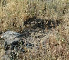
After a snack and some water, we were ready to head back to the car. Along the way, we met up with several other groups hiking to the top of Oklahoma. Just before we left the top of the mesa, we heard the distinctive buzz of a rattlesnake behind us and to our right. Apparently, the snake had been lying quietly about three feet off the trail as we walked by, but then as the traffic increased, he felt threatened and gave off his signature warning. I walked back (but not too close) to take a photo, and we made a point of mentioning the possible presence of the snake to the folks we met farther down the trail. |
|
|
|
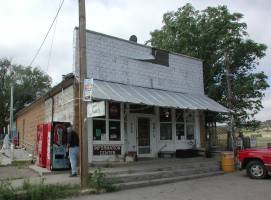
Descending the switchbacks on the jeep trail, the hike back to the car was a bit warmer as the sun rose higher in the sky, but a breeze picked up and some clouds drifted by, keeping the morning from becoming unbearably hot. On the way back to Clayton, NM, we stopped briefly at that Mecca of highpointing, the Kenton Mercantile. It being Sunday morning, the "Merc" was closed, but we can at least say we've been there, even if we couldn't get one of the Oklahoma highpoint certificates that the owner provides. |
|
|
From Kenton, we returned to Clayton, NM, and picked up Marcia at the motel. We headed west toward Taos, NM, pausing at Philmont Scout Ranch briefly on our way. Hopefully, Nathan's Troop will snag a slot at Philmont sometime soon, and we'll spend a couple of weeks backpacking through the ranch. As we approached Taos, thunderstorms had been building over the mountains and we were greeted by a torrential downpour as we drove through town toward our motel. |
|
Once it stopped raining, I took advantage of the improving weather to drive up to the Taos Ski Valley to reconnoiter the trailhead. It was well that I did, since the descriptions were a bit cryptic and it took asking questions of a couple of folks at the ski area to find out exactly where we wanted to go in the morning. The well-marked trailhead on the "Coyote" parking lot at 36°35.798'N, 105°26.945'W is the Bull-of-the-Woods trail that takes a much longer (14 miles round-trip versus 7 via Williams Lake) route but avoids the steep climb from Williams Lake up to the ridge. To get to the Williams Lake trailhead, you exit the parking lot at the extreme uphill corner and take a road uphill and to the right that leads to the "Bavarian" restaurant and the signed Williams Lake trailhead parking lot. |
|
Monday, August 11, 2003 |
|
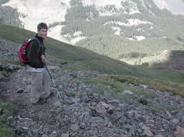
Once again, Nathan and I hopped (crawled?) out of bed at 4:00 a.m. and drove up to the Williams Lake trailhead at 36°34.752'N, 105°26.370'W. We started hiking by first light and remained in shadow until we were nearly up to the ridge above Williams Lake. The hike from the trailhead to Williams Lake is along a good but moderately steep trail, gaining 1,000' in about a mile-and-a-half. Once you reach Williams Lake, a use trail takes off at 36°33.474'N, 105°25.794'W to the east and climbs steeply up to the ridge. Within 3/4 mile, you gain roughly 2,000' from a little over 11,000' to 13,000' at a shallow saddle not far from the summit. |
|
|
|
The views as you ascend are spectacular, with the ridge line across the valley catching the morning sunlight as the valley remains in shadow. At points, Williams Lake is visible as you climb, reflecting the rocks and trees beyond in mirror-smooth waters calmed by a lack of breezes. |
|
|
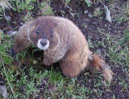
We were greeted by several marmots as we climbed up the slope consisting variously of grassy ledges and blocky talus fields. This particular moocher was not to be dissuaded and followed us for some distance. It was bold enough to come right up to us and sniff our boots when we stopped for a brief water break. A hundred feet or so farther up the slope, we entered the territory of a larger and more defensive marmot, and this medium-sized guy was summarily dismissed by his superior, who insisted on chasing him a good 150 feet down the slope, much to our amusement. |
|
|
|
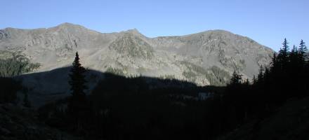
Nearing the ridge, we were finally greeted by the sun rising over the saddle. As it did, Nathan and I cast particularly long shadows back down the steep slope we had just climbed. Some of the ski runs from Taos Ski Valley are visible on the right, showing how far we had come by car and by foot from the resort itself. |
|
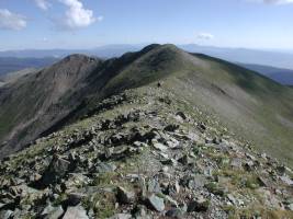
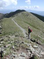
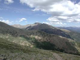
Once we attained the ridge, we were greeted by the first in a short series of false summits. Looking back north along the ridge, you can see the saddle where the trail drops down toward Williams Lake on the left. Fortunately, the false summits are neither steep nor particularly high bumps along the ridge, and a quarter-mile or so of hiking along a good use trail takes you up to the summit, proper. |
|
|
|
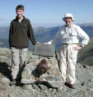
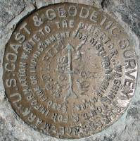
We arrived at the summit at 9:20 a.m., followed a few minutes later by a couple of backpackers who had approached from the opposite side. We shared picture-taking duties and observed that we probably wouldn't be sticking around the summit for long, since puffs of clouds were already forming over the higher peaks in the area. I recorded the summit location at 36°33.409'N, 105°24.982'W, took my usual summit panorama and took photos of the summit marker and two benchmarks we found in the summit area. By that time, the puffs had blown over us and were starting to coalesce, so we quickly retreated down the ridge to the trail back to Williams Lake, pausing only briefly along the way to snap a few more photos. |
|
|
|
|
|
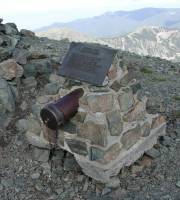
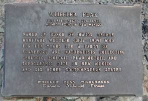
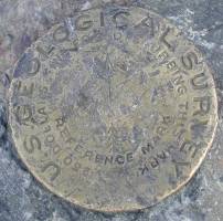
The summit marker is unique, with a plaque commemorating Major George Montague Wheeler, after whom the peak is named, and a sturdy iron pipe holding the summit log. We found a notebook placed there by a local Boy Scout troop and signed in, contributing our names to their list of Scouts and Scouters who summitted Wheeler Peak this summer. There are two benchmarks in the vicinity of the summit, one a reference mark pointing to the summit benchmark, the other the summit marker itself. |
||
|
|
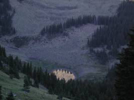
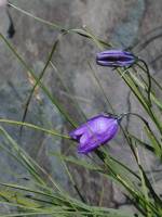
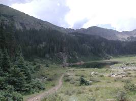
The clouds drifted over at intervals as we made our way back along the ridge and back to the saddle where the trail returns to Williams Lake. The left-hand shot below gives a good idea of the variable quality of the footing along the steep use trail up the slopes above the lake. The intense purple of these flowers brightened up the patches of grass among the rock piles. Once back at Williams Lake, we took a bit longer break and were attacked by hordes of golden mantled ground squirrels seeking handouts from our granola bars. Looking at the photo below and to the right, the trail meandering down toward the lake forks off to the left and leads through the woods to the steep climb up to the ridge. |
|

|
|
|
|
The hike from Williams Lake back to the trailhead was uneventful, although it was punctuated with occasional thunder from the rapidly-gathering clouds over the peaks. It was clear that only the foolhardy among the later hikers we met along the trail would summit that day! We found the Bavarian restaurant was closed on Mondays, but a small pizza place back at the ski resort was open, so we stopped there for lunch before driving back to Taos. |
|
Tuesday, August 12, 2003 |
|
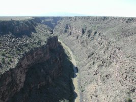
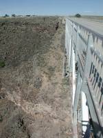
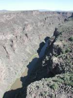
We left Taos Tuesday after breakfast and headed west on U.S. 64 to pick up U.S. 285 north into Colorado. Not far from Taos, the highway crosses a spectacular bridge over the Rio Grande, a perfect spot for another panorama. (515k file) |
||
|
|
|
|
|
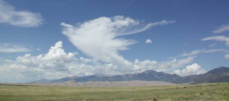
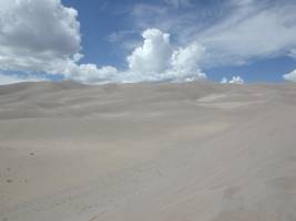
Once into Colorado, we detoured east to the Great Sand Dunes National Monument, a large field of dunes created by the vagueries of wind and erosion. From there, we made our way back to U.S. 285 and continued north to U.S. 24 and Leadville for the night. |
|
|
|
|
Wednesday, August 13, 2003 |
|
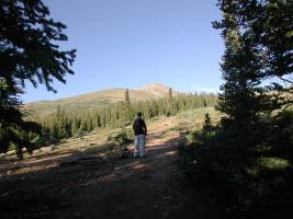
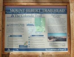
Our third highpoint, our third ridiculously-early awakening. By this time, we were almost used to getting up at oh-dark-thirty. We munched on Pop-Tarts on the way to the trailhead and started as soon as we could start to see the trail at 5:40 a.m. Keeping with my "short and steep" philosophy, we had chosen the North Mt. Elbert Trail which is conveniently accessible from Leadville and provides about a nine-mile round-trip distance and about 4,500' of vertical gain. |
|
The sun rose as we hiked through the woods and was shining brightly as we approached timberline at about 12,000'. The lower part of the trail is pleasant, with gradual slopes and only one short stretch where you lose perhaps fifty feet as the Mt. Elbert trail joins up with the Colorado Trail for much of the ascent. |
|
|
|
Continuing above timberline, the trail steepens and approaches the first and most impressive of several false summits. These serve to punctuate the unrelenting "up" of the North Mt. Elbert Trail as well as frustrate the hikers, who are tempted to believe that each bump on the ridge is the summit. |
|
|
|
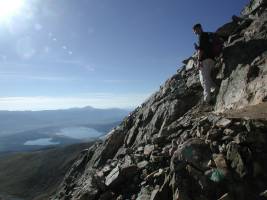
Looking back down the ridge, it is apparent how quickly the trail has gained altitude once it has risen above timberline. There is still plenty of "up" to do, and the steepest part of the trail awaits just ahead, as is apparent from the shot to the right. At intervals, the trail peters out among the rocks and the hiker is left to his or her own devices to pick the best way up. A few spots are sandy enough and steep enough that a fall would be most uncomfortable when you land on the inevitable rocks below. Fortunately, the steepest stretch is mercifully short and you are once again back on a decent trail along the ridge to the summit. |
|
|
|
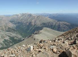
Past the last false summit, up the final bit of ridgeline, and we arrived at the second highest highpoint in the lower 48 states at 39°7.065'N, 106°26.686'W. Checking my watch, it was 9:40 a.m., exactly four hours after we had left the trailhead. We actually bettered my standard estimate of 30 minutes per mile plus 30 minutes per thousand feet of gain by a comfortable margin. We could now relax a bit and enjoy our accomplishment, for the skies were still clear. I took a summit panorama (685k file) and we signed the summit log. |
|
|
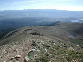
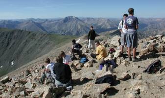
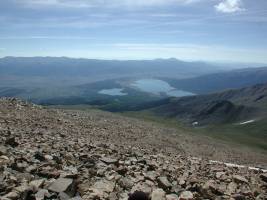
Mt. Elbert is one of the most popular Colorado fourteeners, and we were greeted by a herd of summer camp teenagers when we arrived at the summit. This was one of their off-site adventures, and they arrived in varying degrees of (dis)comfort due to the altitude. Looking around from the summit, you can see Twin Lakes off to the southeast and Mount Massive, the second-highest peak in Colorado, to the northwest. Several of the folks we talked to on the summit of Elbert either had been or were planning on hiking Massive, another walk-up fourteener. |
|
|
|
|
|
|
As the clouds started to puff up, we left the summit about 10:20 and headed back down the trail. Looking over toward Mount Massive again, it was obvious that the pattern of afternoon thunderstorms would continue. We stopped a couple of times to chat with hikers still on their way up the mountain, noting that it would be wise to be aware of the building clouds and any threat of lightning. We arrived back at timberline and found a comfortable log on which to perch for a snack and rehydration stop. |
|
|
|
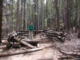
When you reach these log cabin ruins, you are in the home stretch back to the trailhead. In due course, we arrived back at the trailhead, signed in as having completed our hike and headed back to Leadville for lunch. Three highpoints attempted, three attained. Dodging rattlesnakes, killer marmots and lightning along the way, we had succeeded in our goals for this trip. |
|
|
Thursday - Saturday, August 14 - 16, 2003 |
|
When planning this trip, I had built in one weather day each for both Wheeler Peak and Mount Elbert. The weather cooperated, so we didn't have to use either of those days. Instead, we did a bit of meandering around Colorado, driving from Leadville up to Vail and then through Rocky Mountain National Park. Looking at Long's Peak, I asked Nathan whether he wanted to bag another fourteener on the trip, but he declined the offer, preferring to relax for a couple of days. We settled into a motel in Boulder for the final two nights of the trip. Nathan picked a variety of tourist destinations in and around Denver for Friday's tour, including the Colorado Museum of Science and Nature, Wings over Colorado (a flight museum), the Colorado state capitol, Mile-High Stadium and Coors Field. Then, on Saturday, we stopped at the National Center for Atmsopheric Research on our way back to the airport. The flight home was uneventful, and we arrived in good order, having added three more highpoints to our completion list. These three bring my total to 40 and Nathan's to 38. Marcia, not being the hiker, remains at 19 state highpoints. |
|
Respectfully submitted by
Alan Ritter, August 2003 |