No Rock on Ritter...Mt. Ritter (13,150') Trip Report 7/3/98..7/7/98

Recon -- Approach -- Summit Attempt -- Back to Civilization -- Route Description -- Contact

Cast of characters:

Yehuda Ben-David, Nancy Wolfe (Oakland, CA)
Owen Maloy (Mammoth Lakes, CA)
(advisor but better sense than to come along)
Alan Ritter (St. Louis, MO)
(organizer/scribe/de facto leader)

Prelude...

The group had been larger when originally planned, but due to a variety of circumstances, only the three of us ended up going. I flew from St. Louis to Reno on Friday, 3 July, and drove down to Mammoth. After the 5:30 re-opening of the Minaret Summit road to private traffic, I drove over the ridge to Agnew Meadows to survey the situation at the trail head. The water running across the road back to the trail head had subsided somewhat from Owen's report earlier in the week, but there were still big drifts of snow in the parking lot, and signs warning that the area was closed to vehicles. So much for being able to drive ourselves to the trailhead.

Saturday, July 4...Acclimation and Recon Hike...

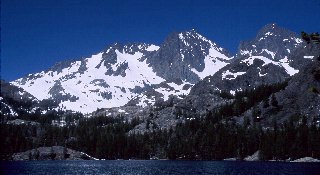
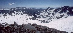
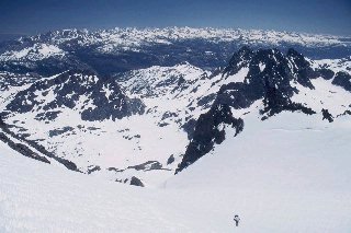
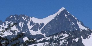
Owen and I met up on Saturday morning to do a little recon hike on the west side of Mammoth Mountain. We drove up to the parking lot at Minaret Summit, driving between walls of snow still six to eight feet high in spots, carved out by the snow plows. From Minaret Summit, we could see Ritter and Banner still cloaked in their winter finest, looking much more like the winter postcards sold around Mammoth than a typical 4th of July weekend.

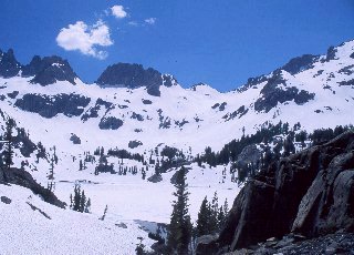
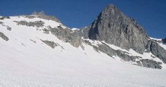
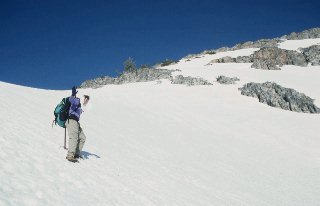
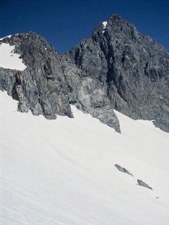
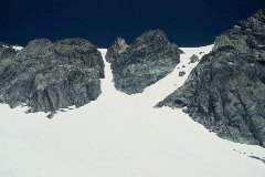
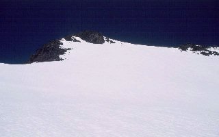
We crossed over the Minaret Summit Road and headed up toward "Wooley Peak", myself on foot, and Owen on skis, initially. However, after 100 yards or so, Owen decided the sun cups were more conducive to walking than skiing, so we hoofed it on up on the west side of the Mammoth ridge to a vantage point from which we could survey the planned summit route.

Owen's suggestion for getting up the prominent buttress which stretches from the southeast glacier to the upper bowl and summit slope was to use the left chute, as marked on the larger copy of the image above.

Nancy and Yehuda arrived the evening of the 4th, and we packed up our gear for the next day's hike in.

Sunday, July 5...Agnew Meadows to Ediza Lake...

With the parking lot at Agnew Meadows were still closed, we had to pony up the $9 fee at the Mammoth Lodge for a shuttle ride over the top and down to Agnew Meadows. That also made for a bit later start on the trail, but with only seven or eight miles ahead of use, we were not pressed for time. In a short time, we were up the steep grade from the river crossing to Shadow Lake, where we were treated to the classic view of Mt. Ritter and Banner Peak.
The hike in was pleasant for the most part. There were still significant snowdrifts over the trail even as it passed through Agnew Meadows (8,400'), but the trail down the slope to the San Joaquin river was clear, as was the set of switchbacks from the river up to the outflow from Shadow Lake.
Once at Shadow Lake, the snow cover became heavier and more continuous, and by the time we were halfway to Ediza Lake, we were on snow 80% of the time, following the "i" (Inyo) blazes on trees by looking DOWN to knee level or even down into the tree wells to see them. Only the rocky ridges were free of snow, and those generally required climbing up on snow in clefts to get up onto the rocks. Owen hit his day-hike turnaround time and headed back to Mammoth, wishing us well in our attempt the next day.
As we approached Ediza, we found that the snow still bridged Shadow Creek in spots, but looked awfully tenuous, with lots of holes and thin spots. As a result, we didn't try to follow the use trail which parallels the creek, but scrambled higher up onto the rocky slope above the north side of Ediza. What a view! Ediza Lake was still 95% frozen, with just a small area of open water at the outlet to Shadow Creek. The main inlet creek on the west end of the lake was still mostly bridged. There was absolutely no bare ground anywhere around Ediza. Just the rocks sticking out here and there, and, of course, the tree wells.
We chose a campsite above Ediza in the shelter of some trees with a nice flat granite outcrop nearby for our kitchen setup. With the bear bags hung and a day-and-a-half worth of food in a BRFC, just in case, we settled in for the night.

Monday, July 6...Summit Day...or so we Thought

Yehuda and I got up early (we thought) and headed up about 6:30. The plan was to climb up via the Southeast Glacier and on to the summit of Ritter.
We started out in the right gully up above the west end of Ediza, then made a slight but annoying mistake in not going high enough up the gully before turning to the right. If you look in the photo below, we turned right just above the rock with the scrub trees on it, only to find that we needed to be a couple of hundred feet higher in order to avoid some serious rock climbing.
That error cost us nearly an hour of head-scratching, scrambling, and backtracking before we were back on-route. From there, we went over a low ridge and contoured around a bowl which is hidden behind some lower humps as you look up from Ediza. We reached the Southeast Glacier in good time, and took a short break on the big rocky outcrop in the middle of the glacier.
From the outcrop, there is a terriffic view to the east, with the still-snowbound Nidyver Lakes to the left and Ediza lower and just to the right of center.
Looking to the northwest, the two primary chutes through the buttress and onto the upper snow bowl were clearly visible, forming a prominent 'Y' with their snowpack extending all the way down to the glacier. The left of these two chutes stopped John Fraser and me in 1994, and the two of us never even saw the right-hand chute, as we were onto the rock and into difficult scrambling even before reaching the branch of the 'Y'. With full snow cover, either would have gone fairly easily, but we were after yet an easier route, farther to the left and on the uphill side of the buttress.
The remainder of the southeast glacier was an easy snow slog through moderate to deep sun cups up past the "three-toed" buttress and making a sharp right turn into Owen's chute. The chute is rather steep but straightforward, and there was all of 15' or 20' of bare scree at the top to be negotiated before hitting the upper bowl leading up to the summit of Mt. Ritter.
It was getting fairly late (noonish) but we still felt confident of making the last 1,200' of the climb. We crossed the upper bowl and headed up-slope toward the summit ridge. Here, we found tracks of a ski mountaineer who had been up there the day before, and followed these rather than breaking a trail afresh. As we neared the upper left corner of the slope, the snow thinned out, and we started postholing. Both Yehuda and I had fallen through hard enough to get our crampons jammed in the packed snow and rocks as we fell, and we used valuable time and energy extricating ourselves.
At 12,600', a mere 500' or so below the summit, we approached our turnaround time of 2:00 p.m. By that time, we were both weary after the past couple of hundred feet of tenuous snow, and were making very slow progress. We tried briefly heading back out toward the middle of the slope, but kept punching through the thin spots. Knowing it was late already, that we were extremely tired, and that it was time to turn back, we reluctantly headed down without getting to the summit ridge.
The climb back down was uneventful, but once we got down to the still snow-covered meadow above Ediza, we had a bit of difficulty locating our campsite without the usual summer landmarks, so it was 6:30 by the time we reached camp again.

Tuesday, July 7...Back to Civilization

The next morning, we discussed whether to stay around and rest a day and give the mountain a second try on Wednesday. We rapidly reached the consensus that we would be better off waiting a year and trying again in 1999. We are both convinced that our best bet will be to use the same route again (it definitely goes easier than any other I've tried), but to plan on a bivouac on the rock in the middle of the SE Glacier, cutting at least 1,500' off the summit day's climb and therefore greatly increasing the chances of success.

A few last photos of the campsite, then time to pack up and call it a trip.

The hike out went smoothly...just a couple more days of melting had opened up much more of the trail, plus the main inlet creek to Ediza had broken through from the lake up into the drainage from which it flows. From the looks of it, it would NOT be a fun time to try and wade it...wide and fast and certainly over knee-deep, and c-o-l-d, for sure! We arrived back at Agnew Meadows in plenty of time to catch the shuttle back to Mammoth. Nancy and Yehuda checked into a motel and I borrowed their shower to wash off the trail dust before returning Owen's BRFC and heading up to Reno so I could catch the 6:35 TWA flight back to St. Louis in the morning.
If this had been planned as a reconnaissance trip, it would be 100% successful. We now know exactly the route to follow and are prepared to give it another try next year. As a summit attempt, well, we fell (oops, bad choice of words!) just a bit short, so our names are still not in the log at the top, but they will be, some day!
It will be interesting to once again watch the snow fly around Mammoth and plan for a 1999 repeat of the "Annual Pilgrimage"...

Illustrated Route Details


Respectfully submitted by organizer, scribe, and erstwhile leader...
Alan Ritter July, 1998