|
| This would be my seventh attempt at my namesake mountain, climbed first in 1872 by John Muir. Two of the previous attempts had been ended by bad or threatening weather, and the other four by a combination of bad route information and a certain level of conservatism about climbing lousy metamorphic rock. It would be Yehuda's third trip up with me, and would have been Pat's second, save for a broken car just before the trip last year, which prevented him from getting there. |
| Lambert airport was a real zoo. Checked bags at the curb, since the check-in line stretched all the way out of the terminal. I stood around as long as I dared, but my bags were still on the curb 50 minutes before flight time. Hope they made it onto the plane! We'll find out in a couple of hours. Despite the long lines upstairs, check-in at the gate was uneventful, and I made it onto the plane with time to spare. The flight pushed back right on time (8:50 a.m.), so TWA met their on-time goal on this one, at least. It was a smooth flight, with clear skies. |
| The plane made good time, arriving in Reno nearly 20 minutes ahead of schedule. Baggage took less than 10 minutes to arrive, and my bags were among the first off (hmmm...does that mean they were last on???). I picked up my rental car at Alamo (too bad...they were out of the compact I had reserved, so had to give me a mid-size at the same price). I drove over to the Sierra Trading Post store and did some shopping, as is my habit on these trips. Found a couple of bargains, plus one thing I had seen in their catalog...a battery-powered LED flasher nominally meant for bicycles, but just the thing to clip to your tent as a beacon to home in on if you are coming back to camp after dark. |
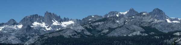
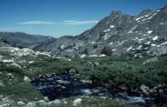
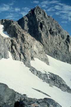
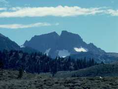
| The drive down to Mammoth took the usual 3 hours, with a couple of soda and stretch stops. Looking to the west as I passed the Shell station at the south end of the June Lake Loop, I greeted Banner Peak and his taller brother, Mt. Ritter, our goal for this trip, through a gap in the intervening hills. |
| I stopped at the Mammoth ranger station and checked their trail condition notebook (nothing more recent than two weeks old, which is typical, so I left them a copy of Dana Chaney's report which he had emailed to me just the day before.) I checked into the motel and hauled everything into the room. |
|
By that time, it was approaching 5 p.m., so I headed up
to Minaret Summit to do an initial intelligence run for
the upper part of the climb. It certainly looked a LOT
different from last year. Between six feet less snow and
being here three weeks later in the season, the upper bowl
was probably 2/3 devoid of snow, so we would have a talus slog
from at least 12,000' on up. That may work in our favor...we
shall see.
I also drove down to Agnew Meadows, where the mosquitoes swarmed around me in 30 seconds. We would have to apply bug gunk BEFORE we got there on Monday morning. |
Note: I am now thoroughly convinced that Dana and Vince climbed a VERY steep and exposed chute which is clearly visible even from Minaret Summit. Owen's Chute, on the other hand, is hidden from view unless you know to make a U-turn immediately after you pass the "three-toed" buttress. From a distance, their chute looks every bit as scary as Dana's description, and certainly leads to the ridge considerably south of the upper bowl. |
| Time for dinner, then time to start organizing and packing gear. |
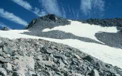
| I took my time getting going Sunday morning, sleeping in late until about 7 or so. After checking the weather forecast (still nice through the five-day period), I walked across the street to Blondie's for pancakes. I drove back up to Minaret Summit as a base of operations for checking out our proposed climb route. Walking south first, I located the clearing from which Owen and I had viewed the middle and upper parts of the route last year. The upper bowl is clear of snow from the ridge at least halfway down to the exits from the chutes up from the glacier. Owen's Chute looks to be partly snow, partly dry, but he maintains that it climbs easily either way. Certainly, the top part of the climb will be a talus slog, but at least we shouldn't have last year's problem of punching through thin spots in the snow. |
|
|
After a few photos, I meandered the 3/4 mile (per my GPS) back to Minaret Summit. From there, I headed north along the Jeep trail which ends up at Deadman Pass. I stopped perhaps halfway to that point, about a mile-and-a-half north of Minaret Summit, since that area was high enough to see the lower part of the climb, but not so far north that Mt. Ritter blocked any of the view I needed. |
|
The gully we plan to climb up from Ediza is
still mostly snow-filled, and the landmarks for our turn point
look the same as last year. We'll go above a rock with a
prominent single tree, and turn right above the next ridge of
rock. From there, the snow bowl looks very much like last
year, and from there we will be on the Southeast Glacier,
proper.
I drove back to Mammoth and called Owen Maloy and Rich Calliger. Rich was still iffy about whether he would make it the next morning, so his joining the group will be a spur-of-the-moment event. I had lunch with Owen Maloy, then returned to the hotel to finish packing. Yehuda and Jason called about 6:30, and we met up for dinner at the Mountain Cafe, along with Owen. We discussed plans for the climb, and Owen assured us that it was "a walk-up". We agreed to meet at Agnew Meadows the next morning at 7:00 a.m., to beat the 7:30 closing of the Minaret Summit Road. |
|
| I got up at 5:30, finished loading the car, and met Jason for breakfast at Blondie's. He walked back to the Motel Six, and I walked across Main Street to the Econolodge. We all made it over to Agnew Meadows in plenty of time, and I drove to the second trail-head parking lot in search of Pat Ibbetson, who had planned to drive over the night before and just sleep in his truck. Sure enough, Pat was there and still sawing logs. It turns out that he had not arrived until 2 a.m. (something about leaving his boots in Sacramento and driving half the night to fetch them) He said he would catch a few more winks and meet up with us at Ediza Lake. | |
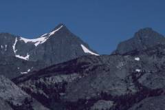
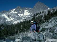
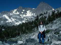
| I filled up my fuel bottle from Yehuda's gallon can, made a last check for anything missing, and we were off toward Ediza Lake at 8:00 a.m. We made good time, pausing at the bridge across the San Joaquin River and again at Shadow Lake, there to take our first look at Mt. Ritter. |
|
| Jason was suitably impressed, and we continued along the trail. We arrived at Ediza Lake about noon, and made our way around the north side of Ediza, scrambling over a hundred yards of boulders rather than walking around the south side, which is a half-mile longer, involves a couple of stream crossings and meandering through a large swampy meadow that is a perfect breeding ground for the clouds of mosquitoes which infest the area immediately around Ediza. Jason stopped to sink a food cache in a hidden spot near the shore, since he will be doing a through hike of the John Muir Trail in August. Hopefully, his waterproof packaging really will be waterproof and his cache will remain hidden from both four-and two-footed raiders. | |
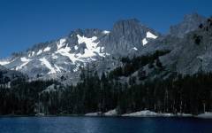
| We made our way along the use trail up the first gully past the boulder field and encountered our first snowdrift in a sheltered pocket on the north side of a large granite outcrop at about 9,300'. Shortly, we found a suitable campsite, complete with Yehuda-approved bear-hang tree, at about 9560', per my Casio altimeter watch. Jason and Yehuda headed back down to Ediza for an afternoon swim in the chilly 57-degree water, while I wandered up to get a closer look at our proposed route for the next day's climb. |
| As I strolled across the braided-stream area between Ediza and the base of the Ritter/Banner glacier, I heard someone call my name. It was Pat, who had apparently rounded Ediza and either missed us or, more likely, simply headed up the wrong drainage, since there are several gullies up from Ediza, each with use trails. I finished my reconnaissance and joined Pat to show him where we had camped. |
 |
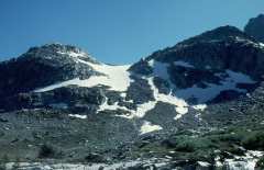 |
The recon was valuable, since the gully we planned to follow as the initial part of our climb was mostly filled with snow, but terminated a series of rocky waterfalls which would have been a pain to climb. There was, however, a series of grassy ledges and rocks to the left on which would be easy to hop up high enough in order to reach the snow above its wet terminus. |
| When everyone was in camp, we discussed the plans and route for the climb. Yehuda's idea was to treat this as an Alpine ascent, by getting up at 3:30 a.m. and starting the walk over to the base of the climb using flashlights at 4:00 a.m. This schedule caused great wailing and gnashing of teeth from Pat, who was already sleep-deprived from his late-night arrival. Ultimately, he acquiesced, warning us that he is not a morning person, but would get up and moving with us. | |
| After dinner, we packed our day packs for the summit attempt, put the next day's food into BRFCs, hung the rest of the food out of reach of bears, and settled down for what would be an all-too-brief night. | |
| 3:30 a.m. rolled around all too quickly, especially considering that I had slept only fitfully, thinking about the climb. A quick cold breakfast, and we were on our way about 4:15 a.m., following the use trail up to a point level with the start of our climb, then turning left across the valley to the grass slopes leading up to the lower gully. By first light at 5:00 a.m., we were poised to start climbing for real. |
 |
 |
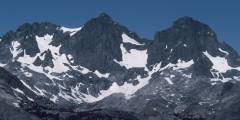
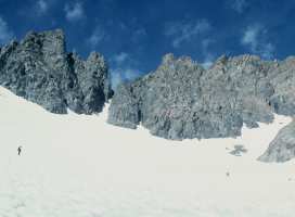
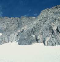
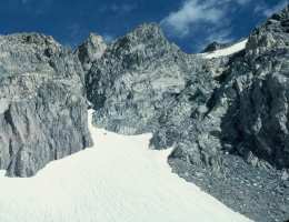
We made good progress up the lower gully on snow firmed by overnight temperatures in the 40s. We passed the scrub trees where Yehuda and I had made our time-consuming mistake last year, and continued up to the top of the gully to make our right turn toward the snow bowl and Southeast Glacier. With six feet less snow, and three weeks' more summer melt, the scene was markedly different from 1998. The route from the top of the gully to the snow bowl was over pleasant solid 2nd-class rock. |
| The snow bowl was still mostly snow-filled, and there was the usual trail over the drifted ridge and onto the glacier. The ridge this year had been wind-sculpted into a more severe peak, pushing us onto 3rd-class snow conditions, as expected. We were on the glacier by 8:00 and took a short break on the large rock outcrop near the bottom of the glacier. Pat moaned over the amount of the climb that would be on snow, as he is not as comfortable on snow as on rock, and slows down a bit out of caution. |
 |
|
|
|
|
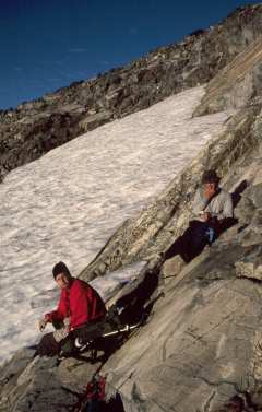
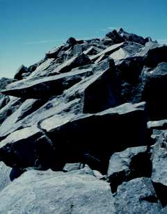
By 9:00, we had reached the third toe of the three-toed buttress and made our U-turn into Owen's Chute. It was totally devoid of snow, and presented a jumbled slope of talus and scree. Yehuda and I headed up the left side of the chute, as this was the easier area when snow-filled, as it was last year. Jason paralleled us perhaps 50 feet to the right and, as it turns out, picked a better line, as Yehuda and I ended up with 20 or 30 feet of 3rd-class climbing to reach the top of the chute. With Jason already waiting for us and giving pointers, we wasted fewer than 5 minutes on the 3rd-class pitch, and reached the upper bowl by 10:00. |
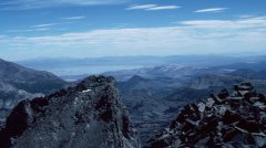
| From there, we could see a relatively flat snowfield which we crossed without crampons and the talus slope leading up to the summit ridge. A second, steeper, snowfield stretched part-way along the upper slope, and we skirted the left edge of this snow, since it was faster and easier to stay on the rock. There are actually the traces of a use trail visible in the gravelly areas amidst the talus, so route-finding is easy at that point. We passed the false summit which looks so tempting from below, going to the right of this rather steep outcrop. I was lagging just a bit behind Jason and Yehuda when they reached the summit ridge. A minute or two later, I spotted them sitting on the ridge, motioning me on and saying that the summit was mine to lead. There are two bumps on the west end of the ridge, the second one being a few feet higher, and it was a simple, but exciting scramble those last 100 or so feet along the ridge to the summit log in its cast-aluminum box. |
|
|
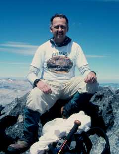
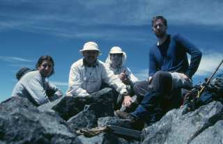
10:45 a.m., July 27, 1999, was the culmination of a 14-year, seven-attempt odyssey. Yehuda snapped a first photo of me standing triumphant on "my" mountain. Then he and Jason scrambled over to join me and sign in the log. Pat caught up with us perhaps five minutes later after a few pointed remarks about the last scramble and the exposure to the north side of the ridge, which is extreme, to say the least. |
|
| We savored the view from the summit, took pictures with Pat's, Yehuda's, and my cameras, and spent an hour or so on the summit, heading back down about noon. We retraced our route down noting Jason's easier, all-2nd-class path through Owen's Chute, back down the Southeast glacier on softening afternoon snow. Jason tried valiantly to boot or butt glissade, but most of the glacier is either too low in angle or too sun-cupped (or both!) to allow long glissades. The rest of us settled for down-climbing or short slides into sun cups, and Jason was waiting at the bottom of the glacier for us. |
 VR Movie of 360-degree panoramic view from the summit. Note: This is a 700k file, so be prepared for a bit of a wait! |
|
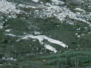
The hop back over the snow ridge and into the snow bowl was a bit tenuous on the sloppy snow, and each of us slipped enough once or twice to remind us how to self-arrest. Pat was the only one to take a more serious slide, which he arrested safely, but not quickly enough to avoid giving himself a good fright in the process. Once again, over the rocky ridge and into our gully, which seemed a bit steeper by virtue of its softer surface. Here, Jason could build up a fair head of steam on his glissades and beat us down the 500' of the gully by a large margin. As we scrambled down the grassy slopes, I spotted the interesting rock formation in the photo to the left. It appeared that an ancient climber had fallen and remained face-down in the brush, turned into granite by some chance of fate. A casual walk across the streams to the use trail, and we were safely back in camp by 5:30 p.m. |
| It had taken us 6-1/2 hours to reach the summit, and about 5-1/2 to return. Over 7,000' of total "up" plus "down", and we were tired but happy mountaineers. We managed to find enough energy to fix dinner (well, Jason had so much excess energy that he went down to Ediza for a swim before dinner...ah, youth!!). I pulled two airline bottles of Scotch out of a pocket of my pack, and we drank a celebratory toast to our success. Cutty Sark never tasted so good!! | |
| We awoke about 6 a.m., which felt like "sleeping in" after the previous day! Pat was the first one packed, and left right away, having to get back to Fresno in time to do some "real" work later that day. Jason, Yehuda, and I fixed breakfast, packed up and left Ediza Lake about 8:45. |
|
|
| We paused for photos at the outlet to Ediza and again at Shadow Lake. My repaired Achilles tendon was bothering me a bit, so I fell perhaps 15 or 20 minutes behind Jason and Yehuda on that last miserable 400' climb back up from the river to Agnew Meadows. I reached the parking lot about 12:30, poured my leftover fuel back into Yehuda's gallon can, and packed up the car. Jason and Yehuda headed back for the Bay Area, and I drove down to Devil's Postpile, where I knew there was a handy pay phone. | |
| A first call to TWA to change my return flight to Thursday instead of Sunday, then a call home to let Marcia and Nathan know that I was off the mountain safely and, yes, I had made it to the top!! One more call, to let John Fraser, my climbing buddy of many years, know that I had done it, and then time to head back to civilization. | |
| On the way out of Mammoth, I stopped at the ranger station to fill out a trip and trail report. While there, I ran into a father and son who were planning to climb Mt. Ritter from the west side in a couple of days. We swapped stories, and I cautioned them that their plan to camp at Thousand Island Lake and to climb Mt. Ritter as a day hike from there might be just a little bit aggressive, having been back there and knowing what a slog it is from North Glacier Pass down to Lake Catherine, and that it is a fairly tough cross-country route from there to the base of the climb from the southernmost of the Ritter Lakes. I left them a business card with my email address and hope to hear back from them when they return. | |
|
A chicken sandwich from McDonald's and I was on my way.
Just south of Lee Vining, I stopped at my favorite spot for
a last view of Ritter and Banner, no longer mocking me, but
now old friends peering through the afternoon haze.
The three-hour drive to the airport motel in Reno went pleasantly enough. Finally, a shower, a real dinner, and I was almost back to human. Packed things up for the flight, hit the sack at 11:45 with my alarm set for 4:45 to catch the 6:30 a.m. TWA flight back home. |
|
| I should have been suspicious when I walked out of the motel in Reno and there was a black cat curled up on the doormat! The Best Western driver got me to the airport in fine time (well, it's all of a five-minute drive), but when the gate agent checked my ticket and re-booking information on his computer, TWA showed me as booked on the 6:30 a.m. flight for Friday, not Thursday! Of course, the flight is over-booked now, so I am on priority standby. One can only hope for a few no-shows. |
| Success!! Enough no-shows that I made it onto the flight. Because of people running late at the ticket counter, the flight was a few minutes late taking off, but not bad. We arrived in St. Louis on time at 12:05, so the flight was within the slack allowance at takeoff time, anyway. Perhaps the black cat's purpose in life was, instead, connected to the unaccompanied 8-year-old sitting next to me, who got a bit airsick halfway through the flight (but that's another story...) |
Illustrated Route Description |
| Thanks first to John Fraser, who started me on this quixotic quest some 14 years ago, and to my wife, Marcia, for putting up with the whole epic struggle. |
| Second, thanks to Yehuda Ben-David, Pat Ibbetson, and Jason Novak for joining the final, successful, team. (Rich Calliger, you, too, could have been there!) |
| Thanks also to a long and varied list of participants in the various iterations of the pilgrimage: My son, Nathan; John, Lindy, Andy, and David Fraser; Lori McConnell, Jesse Kingsley, and Martin Jabs; Tom and Ed Milner; and Yehuda's wife, Nancy Wolfe. |
| Finally, thanks to all of of the PCS folks, especially Owen Maloy for his route information, and everyone else for information, counsel, and encouragement over the years. |
| Now I can get on to some other peaks...state highpoints like Mt. Whitney and Boundary Peak, and other interesting peaks like Shasta. |
|
Alan Ritter |