|
| Disclaimer: Mountaineering poses significant risks. The route description which follows is not meant to train anyone in climbing techniques. If you fall off the mountain and break your fool neck or any other part of your anatomy, do not send your lawyers, heirs, etc., after me, or whomever. You decided the rewards were worth the risks and you accepted those risks when you left the trailhead! |
|
The following route description and illustrations represent the
evolution of a route which has been developed over three trips up
to Mt. Ritter. For a different look at this route,
please check out my
1998 route description, which describes the same basic route,
but under vastly different snow conditions.
The winter of 1997/1998 saw well over 500" of snow at nearby Mammoth Mountain, and we made our 1998 attempt in early July, camping on snow above a frozen Ediza Lake. You can read about that attempt and the overall conditions in my 1998 trip report. By comparison, the winter of 1998/1999 dropped just over 400" of snow on Mammoth, and we were up on Mt. Ritter three weeks later in the summer. As a result, we spent about half the climb on rock instead of snow. The big differences were two-fold: First, we knew the route better and made no time-consuming route-finding errors in 1999. Second, as is evident from the body of this report, we got a very early start on the climb, which helped both in avoiding the brutal mid-to-late-morning sun on the Southeast Glacier, as well as giving us more than enough margin before our stated turnaround time of 2 p.m. Those two significant differences gave us the summit. As far as the route's difficulty, I would rate it (conservatively) as 95% second-class snow and rock. There are a couple of spots of steep (>45°) snow, especially that wind ridge as you get onto the Southeast Glacier, and Owen's Chute can be done either on solid second-class talus and scree, or up a couple of hops of low third-class breaks. I would also caution that the final summit ridge is very exposed to the north and should be treated with all due respect even though it is a pleasant scramble. Note: Images in this description which show as links point to large copies of the same image. Please be aware that they are often greater than 1k x 800 pixels and will take a while to load. However, the visual detail provided may come in handy if you try to follow this route. Ok, enough background! Let's get to the route itself! |
|
|
|
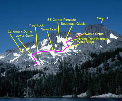
The view from Shadow Lake provides a good vantage point for looking
at the lower and middle parts of the climb. Important landmarks are
the dome to the left (south) of the desired lower gully, the "tree
rock" about 1/2 to 2/3 the way up the gully, the pinnacle at the
corner of the Southeast Glacier, and the "three-toed buttress" which
marks Owen's Chute.
The next photo will show the very bottom of the climb, but once you are in the lower gully, go almost to the top before turning right over the ridge. If you turn at the "tree rock", you end up in some nasty 3rd and 4th class cliffs, as Yehuda and I did in 1998. Going all the way to the top (or nearly so) leaves you an easy 2nd-class scramble over the rocky outcrops to the snow bowl. You then contour around the snow bowl, staying low enough not to risk a fall into the gap between the snow and rock, and to find a relatively-less-steep point to cross the wind ridge which diagonals down from the pinnacle. You then turn up the Southeast Glacier and continue up past all three "toes" of the three-toed buttress before making a sharp right turn (almost a U-turn) into Owen's Chute, which is hidden behind the buttress in this view. We'll pick up the top part of the climb after a couple more detail photos along the way. |
|
|
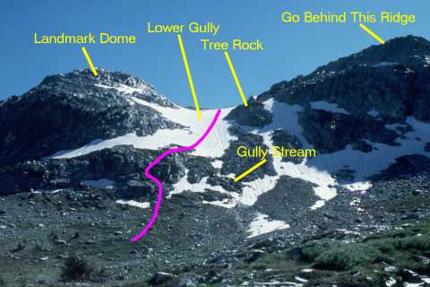
Standing in the glacial valley above Ediza Lake, where the exit
stream braids its way among the granite outcrops, you will get
this foreshortened view of the lower gully. The features are
identified as on the previous view, and it is obvious from this
view that you can get confused about where the "top" of the
gully is, due to the varying slope of the snow, which is steeper
in the lower stretches and flattens out a bit after a ridge about
halfway up.
The landmark to avoid is the "tree rock". Keep going well above this and go above/behind the ridge at the upper right in this photo. The stream which exits the gully lobbies for starting the climb either to the left (as we did) or to the right of the gully. You could also go a bit farther to the left and dodge some of that lower outcrop, but it's just a scramble, nothing more, so is easily and quickly overcome. |
|
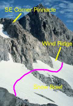
Once you walk over the rocks, you will see this snow bowl. This
year, there was a tongue of rock sticking down from the pinnacle
at the corner of the glacier, but it was narrow enough at the
top to walk across without removing crampons.
The process here is simple...contour around the bowl, staying well below the snow/rock line, and then climb over the wind ridge at the far side of the bowl. The wind ridge is the only place the snow is really steep, clearly more than 45°, so a bit more caution is advisable for that short pitch. Once over it, you are onto the Southeast Glacier, proper, and the climbing is again easy on moderate-angle suncupped snow. |
|
|
|
|
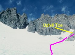
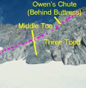
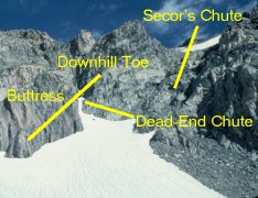
As you leave the large rock outcrop at the snout of the Southeast
Glacier, you see its expanse spread out in front of you. Immediately
above you and to the right are Secor's chute and a steep, narrow,
dead-end chute full of really slick slate. (I know whereof I speak
from my 1994 attempt which ended in that chute.)
Secor's chute is blocky but doable, although the snow headwall above it can be intimidating, depending on how the winter storms blew in and how steep the slope is on the snow. Owen's Chute, just beyond the uphill "toe" of the "three-toed" buttress, is the easiest route to the upper bowl. If you stay to the right of the rock outcrop in the middle of Owen's Chute, it is moderate class 2 talus and scree. To the left, there are a couple of spots of not-particularly-difficult third-class rock, so it works either way. |
|
|
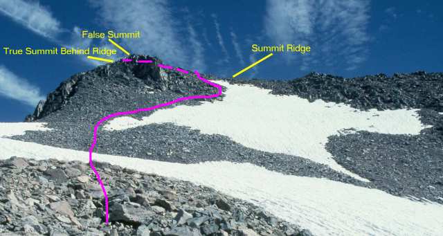
When you reach this point, you are really in the home stretch.
You have about 500 vertical feet to climb, and on the rock, it
is an easy stretch, save for the fact that you have to watch
for the wandering oxygen molecules and snag the few that meander
by!
From the top of Owen's Chute, the route is quite straightforward. You cross the lower snow field, which is at a shallow enough angle not to require crampons, then skirt the left edge of the upper, steeper snow field until you reach the summit ridge. A couple of hundred feet of basically horizontal scrambling along the ridge take you to the summit, proper. Do mind the exposure to the north, though. It would be a quick but painful trip down if you went over it to that side. What appears to be the summit is actually a bump on the upper slope which sticks out far enough to be tantalizing, but is a bit lower than the ridge and true summit, which are obscured behind it in this view. From this point, it took us about 45 minutes to reach the summit on an absolutely gorgeous day. |
|
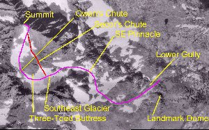
This annotated image, made up of USGS orthophotoquads, shows an aerial
view of the whole climb. Obviously, the USGS photos were taken in
a somewhat drier year than either 1998 or 1999, since there is quite
a bit more exposed rock than there has been lately.
The image links to a medium-sized (600-pixel) copy of the image. There is an even larger, 1500 x 900 pixel, image available if you have the patience to download it. |